Saturday, September 26, 2009


Devil's Pulpit (upper left) and associated cave - right; Connecticut River Valley

Devil's Pulpit and Cave


The goals on this trip were to find another access point, and to do a bit of good old reconnaissance. The site was once again the marvelous rock features within the Connecticut River Valley and was once known during the 1800's as a natural 'park'. Although I now have dozens of trips behind me when it comes to this area, its uniqueness cannot be understated. No where else in Massachusetts is so much incorporated into one area.

With that said, entrance to this section of the former 'park' was made by way of Mitchell Hill. This is one of many archaic names now long forgotten by both the modern generation and even the local residents. Making my way up the remains of a past mountain road, that once saw many a horse and carriage, I found suitable parking.

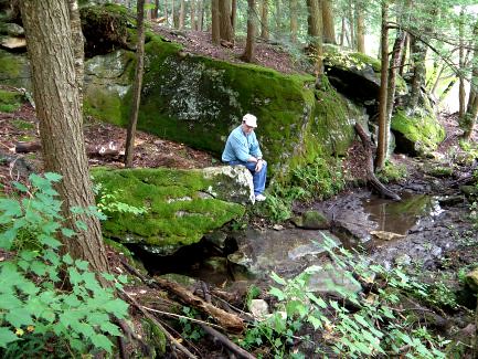
When the area was written about some 140 years earlier, the writer was very eloquent in painting the landscape with many a quaint term. One such description used was 'shelves' to describe the many ledges of rocks one encounters while ascending and roaming about the mountainside. Indeed these shelves diverge, converge, and disappear altogether.

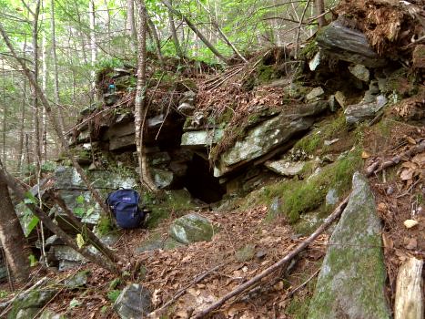
My ascent was made steeply on a slope, stumbling upon the small pieces of arkose and conglomerate. On reaching my first plateau backed by a conglomerate 'shelf', it was time for the exploration to begin. Back and forth - weaving from one level to another - I finally stumbled into a 'devil's pulpit' formation with a cave! This shelf yielded many more interesting formations before merging into the main ledge once know as "The Home of the Rocks".

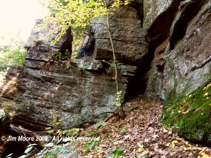
Right about at this point is the glorious Grand Porch, a sort of gigantic open faced shelter that is open on one side with its disintegrated remains forming small talus caves. By retreating along the direction I took, but upon a higher shelf, I took in a number of bear's dens and the area once called Titan's Pasture, a passing remembrance to the ancient Gods of past civilizations. It is not the only such recognition as we also have archaic references to Titan's Quarry, and the Titan's Dooryard.

But at Titan's Pasture is an interesting cave, hidden up in the ledges, with entrance gained only by climbing. This cave is another in a series formed in a manner described by speleologists as gravity slide or gravity assisted. Obviously the action of frost (hence: frost action) plays a part in 'quarrying' these large masses of rock from their parent ledge. But within this cave I was pleasantly surprised to see a bat. A healthy bat no less, free from the dreaded White Nose Syndrome (WNS) that has been ravaging their kind. Fecal matter indicates possibly more than one might use this as their hibernaculum.

Upon the exiting of Cave at Titan's Pasture, a methodical retreat was made down the mountainside checking shelf after shelf to more or less tie the exploration - past and present - all together.

Wednesday, September 16, 2009

That time of the year again - the South Shore adventure and a chance to work most of the Plymouth - and some of the Norfolk county areas.


Traditional site of John Eliot's Pulpit Rock

Day One approach by good old Rt.s 95/128 swinging around the outside of Boston. Landing in West Roxbury ('home' to the state rock: Roxbury Conglomerate) I proceeded to look into a couple of cave formations within. One is the traditional site of John Eliot's pulpit, an early preacher to Native Americans. The second site - like the first - was a split rock formation where the pieces of rock form a crude shelter. So far in my investigations, this is the typical 'cave' in these parts - and these rocks. However, also found in this area a few years back, a small shelter worn out from under a ledge. I believe occasionally used by the homeless.

Before leaving town I took a quick spin through a neighboring town where an early 1900's history mentions a former cave. All built up now, I can only image what might have existed within the area where a few outcrops of puddingstone can still be seen.

Arriving in the glorious Blue Hills, I continued on with a search begun in June of last year. A small, shallow cave by the name of Rattlesnake Den was written about in the very last years of the 1800's. I've theorized where the general area may have been and mapped out a section to investigate. Some fine hiking but no den so I'll give it a go at another time.

A couple of quick sites before setting up camp. To the south of the Blue Hills, a large perched glacial erratic. This was brought to my attention by a reader some years ago around the time I was looking for Squaw Rock in the same town. It may be this rock as one local resident thought, but again it may not. Finishing the day as I swung out towards the shoreline areas was conservation land which brings one within sighting of the Glad Tidings Rock with a couple of legends as to how it got its name.

Day Two began with a early morning walk at the Worlds End property in Hingham. A beautiful piece of property and a section called Rocky Neck which will be worth another visit in the future.

Retiring to a local library, I put in some quality research time before heading down the coast. One of the towns has a history replete with 'devilish' formations, Indian ovens, and a pulpit Rock. I have made several visits over the years always coming away empty handed. But persistence can sometimes pay off and with information gathered on a library visit last year I located their very own Pulpit Rock and a likely possibility for a Devil's Rock with His footprints. Hopefully much more to come out of this town in the future.

Landing back at camp to clean up and eat, I did some light duty by visiting the former site of Great Rock (destroyed) and Turkey Hill: hilltop farm land with views now under the protection of the Trustees of the Reservations. One more library then back to camp for the night.


Pulpit Rock

Day Three: Starting the day out in northern Plymouth County (in the same town where the county's largest glacial erratic lies) I went out to look into the story of a "Devil's Cave" near a major river passing through the area. An old abandoned railroad line provided the access and the 'cave' turned out to be a split rock formation. Other features in the area were Indian campsites, old dams and a factory, as well as a herring run.

Farther south in the land of Bridgewater, I revisited Sachems Rock although my main purpose was to renew an old acquaintance from the immediate area. Apparently they have disappeared but Sachem's, marking an ancient land boundary, still remains. Then on to Minister's Rock with its quaint inscription and a nearby Pulpit Rock.

Slipping briefly over into Bristol County, I connected with the local library to deliver a photo and information on their very own Devil's Footprint. Then on out of town (just barely) to hit another 'cave' attributed to old King Philip. This one is formed by the overlapping of some huge boulders near a hilltop.


Indian/King Philip's Cave

Day Four: The original intention of the South Shore trip some years back was to devote time mostly to the towns of Cohasset, Hingham, Scituate, and even Weymouth. I really had not spent much time in these towns on this trip so as a parting gesture I hiked on in to Wheelwright Park. The park is home to Big and Small Tippling Rock as well as the Devil's Chair. Big Tippling is indeed a worthy boulder at 55 feet in circumference. But its dimensions do diminish a bit underneath as well as on top.

On over to the big event of the day: to meet up with members of a local historical society. The purpose here was to continue on with the search into "Writing Rock". Between the coffee, the crumb cake, and conversation with a number of very learned, very gracious members, much more was gained that information on just one rock. Apparently the rock had symbols matching some on the more famous Dighton Rock and has also been made off with! It's exact location is somewhat unknown.

Before turning the car homeward a brief hike was made into a neighboring town's Town Forest. This also was a continuation of a search started last year for another Devil's Den. It is somewhat conjecture that this devilish den lays in the area (also home to the Garden of the Gods visited last year) but it also may not. Nearby is a section of land known as Rocky Woods and, in the future, I may move my search more towards that direction.

Saturday, September 12, 2009


Insurgence entrance to Great Radium Springs Cave; Berkshire Co

One of the entrances to Great Radium Springs Cave

A regional group of cavers descended upon the central Berkshires for the weekend. I stopped in to say "hello" to the few I might know from ages ago. On the immediate premises was Great Radium Springs Cave which was confirmed as the longest cave in Massachusetts some time ago when two intrepid cavers went through a watery sump connecting sections that were previously visited only through two different entrances. Radium Springs was a nearby spring that produced bottled water and soda during the early parts of the 1900's

Monday, September 7, 2009


The Natural Ice-House/Ice Cave; Franklin Co

The Natural Ice House/Ice Cave


Seems like Fall is beginning to make its way into the Northeast. Some dread it for no other reason than they hate what's behind it - Winter. Personally, it is with out a doubt my favorite time and begins a race to see how much I can get in before Old Man Winter closes my season out.

My objective on this day was a leisurely trip over to the 'far' side of the Quabbin Reservoir. Here in the former Town of Dana (modern day Petersham) I walked beautiful old roads lined by stone walls on my way to a remote hilltop to look over glacial erratics. Many of modest size were present with a good number 'split' by the forces of Nature. One in particular was most interesting as a tree had taken root and grown up by the side of a section of split-off boulder. Upon reaching the top surface of the rock, grew horizontally on the rocky surface before deciding o once more push upward vertically.

There were many stone walls running perpendicular to the main wall of the road that once sectioned off individually pieces of property. Almost no signs of previous habitation could be seen within those boundaries. But in one case a curious stone lined underground chamber did exist.

Upon exiting these woods I drove a short distance further on over to Franklin County. Still much with the realm of Quabbin, I dropped in on the popular Bear's Den, home to a former grist mill, legends of King Philip, and abode to the bears. Although best know for its picturesque falls on the Middle Branch Swift River, it is also home to some interesting speleology. Small caves have developed during the process of weathering out of small sections of the cliffs. Basically two very small caves are able to handle a human but many other "quasi cave" formations show the same forces that created those, are still at working creating future caves.

Returning north to the Mohawk Trail, I visited an access point set up by climbers to visit impressive ledges that also contain fine caves I've examined in past years.

Lastly, I busted the woods through damaged trees and broken rock upheavals to try to relocate the Ice Cave, less than four miles south of the New Hampshire border. Although a previous GPS reading (a device I have mixed feelings for) sent me on a bit of a wild goose chase, eventually it was found. Not much to this 'cave' although local history writes of it as a natural ice house. And cool it was!