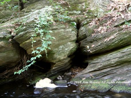
Indian Cave entrancesDay One: brought me into Norfolk County by way of the Mass Pike and Rt 495. First destination was an old canal site along the Charles River and an Indian Cave in the immediate vicinity. The origin of this cave seems quite interesting as a softer, almost chalky, lens of rock (sample now being analyzed) in the surrounding bedrock was susceptible to weathering.
Rocky Woods is a name that pops up in local geographical databases every now and then. I dropped farther south to take a look at one such area. I had started working this area a few years back when a written work on the area mentioned a cave in these woods, a House Rock, and a Great Rock. It is primarily within the region of Dighton Conglomerates and many of these 'puddingstone' boulders and outcrops were indeed to be seen in Rocky Woods. Somewhere in the local area is the site of an old postcard called the Playmate, paying homage to a rock that was played upon by someone's Father during his childhood.
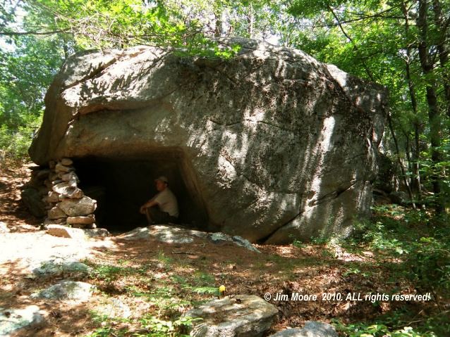
But Rocky Woods are an immense piece of territory and any cave would have to be guided to. I saw no such thing. I did see House Rock once again at the farthest reaches of my hike, another large accumulation of conglomerate boulders forming a sort of small Garden of the Gods/Rock City effect. A gargantuan boulder of conglomerate also exists here with a circumference of 103.5 feet!
While in the general area, I decided to drop in on some of my other favorite conglomerate features laying a couple towns away. Abram's Rock, Wildcat Rock, and Lion (or Lion's Head) Rock are some of these. One having petroglyphs upon it's surface.
Day Two: At dawn I made the trip down into Rhode Island to give my kayak its maiden voyage upon the ocean and finally bring it into use as a bona fide piece of research equipment. My original destination was quite busy even at early morning light so I retreat a bit north where an old ferry route provided ocean access to an area where an old report on bird count mentions Swallow Cave. Sailing the coastline where the ocean is in non stop motion proved both interesting and challenging. The conglomerate ledges of the coast offered many fractures, some even where the sea could get behind, but nothing in the way of a true cave. Perhaps the birds nested with the multitude of fissures to be found along the coast.
The rest of the morning was spent visiting old haunts with the hope of once again putting in the kayak. But - not unexpected - this time of year is not good to visit a tourist favorite such as the Newport area. My springtime trips to the region have always offered the better opportunities at getting into the variety of geologic sites along the coast.
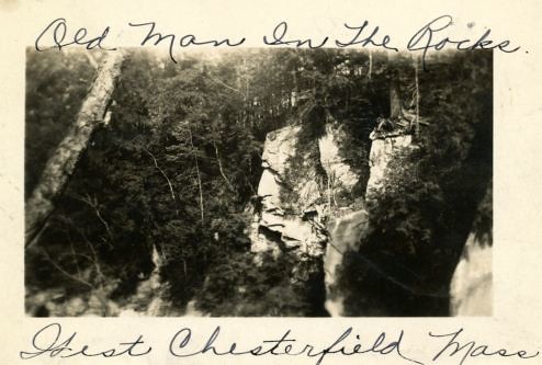
Returning to Massachusetts, I decided to hike in to another Rocky Woods, which was a primary destination and research topic for this trip. It is reported to have an abundance of geologic features, the best being one of the many rocky features know as King Philip's Cave. Other notable sites include Devil's Hoofprints, King Philip's Soup Bowl, and the Devil's Bowling Alley. After departing King Philip's, I headed on over to Profile Rock before finishing up the afternoon at one of the two local libraries in Town.
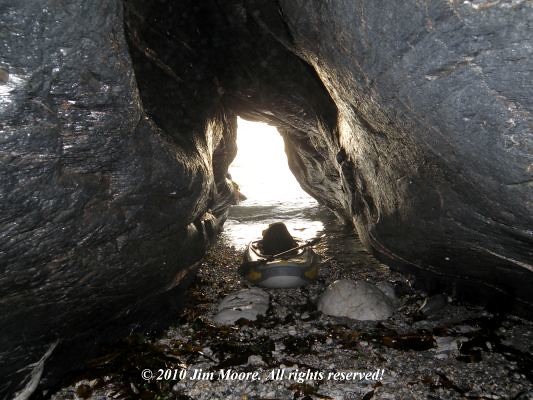
King Philip's CaveDay Three: Driving through the dark, dawn found me once again returning to the Narragansett Bay in pursuit of another cave lead. Parts of this shoreline had been looked over several times in the past with varying results. Small cave, "quasi-cave" features can be found but I was hopeful of finding a real genuine outstanding sea cave! The kayak was brought in through a narrow access strip to the ocean. Putting in, I began a tour of the coast which eventually landed me in an area of features I had looked at in the past. Some inaccessible from the bluffs above. One I got into several years past by means of a rope. One small cave and one quasi-cave formation existed with a small cove. Turning the boat back around I rounded a corner to be faced with a gaping cave entrance within the cliffs. While circling about the outside, the ocean decided to push me closer then on in. Once beached underground I found the cave to be more substantial than it first appeared from the outside. Total length here, probably 50 to 60 feet.
Retreating to a local wifi site I relaxed over coffee catching up on more mundane matters. Eventually hitting the road, I returned to Massachusetts and the library I had waited to open since arriving in Bristol County. Gleaning all that I could from sources there I mad a quick spin out to Joe's Rock, another historical site of human habitation often mentioned as a cave but just some heavily fractured and split rock outcropping. Then returning past the library I scouted the outside perimeter of Rocky Woods for a couple features I learned of during my recent library visit. Finishing off an early day I connected again with Bob, a local antique dealer who has been a valuable source of information over the years on the immediate area.
Sea cave along the Narragansett BayDay Four: was left during the planning stage as an optional day. Sleeping in to 5 am made it too late to avoid the early morning crowds down at the Rhode Island beaches. Besides: the oppressive summer heat was already making its return. So I decided to take one more early morning walk through Rocky Woods to familiarize myself a bit more with its path system. Then with it already 75 degrees by 7 am, I turned the car homeward.