In recent years this aging baby boomer takes himself during September on out to the South Shore area in the Bay State. This year was no different. Stops are often made at various locations both to and fro.
Day One: Ditching off of the Mass Pike for a short jaunt down Rt 128, my first stop was ... a flat tire! Once that issue was resolved, I made my way into northern Wellesley to the Boulder Brook Reservation. Nice area to find in a basically suburban neighborhood but not much for boulders despite it's name. Perhaps it's main feature is a side of Rocky ledge which also marks the boundary with the town of Weston to the north. Nearby is a big boulder (sometimes called the Bates Boulder) in another park - Kelly Park.
A bit to the other side of town are the remains of an old estate from the second half of the 1800's carved up long ago into more suburban neighborhoods. I first visited the area some twelve years ago and found residents - at least the one I talked to - very gracious. Apparently with new owners, the situation has changed significantly. It is now patrolled by security officers. So attempts to update information on this area was largely futile.
Moving on down to The Blue Hills I initiated two searches. Both basically turning up nothing. The first was an attempt to find the location of a Rattlesnake Den written about in an old publication from the early 1900's. I started this last year and continued by covering a slightly different tract of land. Although I saw plenty of rocks on this visit (hey - after all - this IS the Blue Hills!) nothing that would fit the description. A small cave formation called the Hermit Cave by its modern day photographer also did not turn up, but likely just the wrong area was searched.
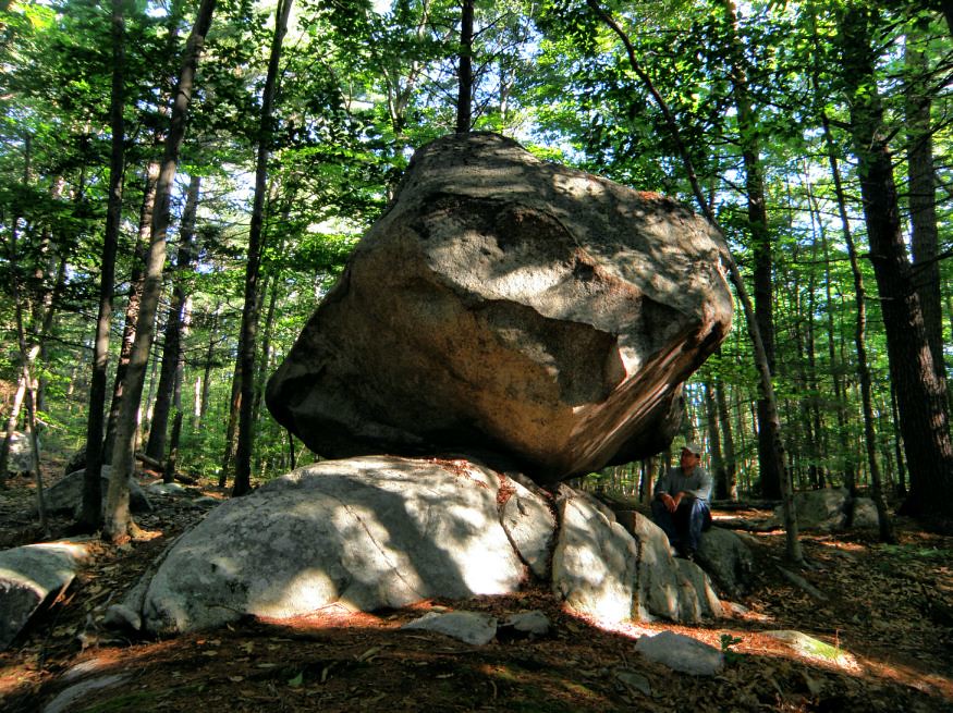
Early morning at the Burbank Boulder Day Two: Early morning brought me to the eastern region of the Wompatuck State Park for a reexamination of a small cave found there several years early. Perhaps Rattlesnake Den might be a good name but then it would confuse matters as history records another site nearby with the same name. But a closer examination shows much of this cave's origin is due to displacement of a large, fractured piece of the parent outcrop. A similar - but smaller situation - would be seen later in the day within the same town. I finished the walk by making a circuit past the Burbank Boulder (incidentally: slightly wrong location is marked on their trail map) and trying (in vain) to find legitimate access to Cleft Rock before breaking at the nearby Scituate Library.
Emerging from the Library I made the short distance to the local historical society to further work on another lost erratic called Damon's Rock. Although it seems after numerous tries, I finally have narrowed its location down. But another site where access may be a dicey situation. But being already down by the ocean, I made the tour up the coast visiting the Nubian Head Rock, Well Rock, and the Old Man of the Rocks before heading back into Cohasset.
At the Cohasset Historical Society, I shoved a recent eBay find under their eyes for possible identification but to no avail. Afterwards, in driving part of the coastline, I caught a distant view of Daniel Webster (profile rock) sitting at the ocean's edge. Down on the boundary between Cohasset and Scituate is a rock at Bound Brook, incorporated into and old mill site. Landing Rock, where I was told baptisms once took place, also lies in the vicinity pretty much shut off by private land.
Great Brewster Woods (access behind the Cohasset Town Hall) is a fine walk and the site of one Lion's Den whose exact location is somewhat lost to history. In the past I thought it to be a marginal cave formation in the far northern parts of the Woods (also formed by displacement of a section of ledge) but now believe it was one of several rocky ridges within the GBW.

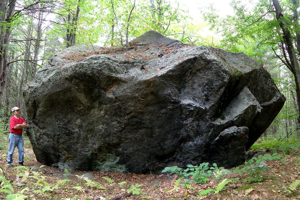
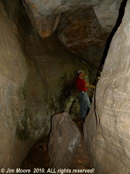
Part of the Cavern Rock complexDay Three: A more leisurely pace than the preceding day, I caught up with some work at the local wifi spot. Then heading into an adjacent town I looked into a reference by eminent geologist Crosby from the early 1900's. He mentions a feature resembling (but much smaller) than nearby Cavern Rock. Indeed a small spot survived amongst much developed land that contained minor rocky formations. Wether any of these were what Crosby had written about is uncertain. But speaking of Cavern Rock, since it was nearby, I dropped on by to update my photos on this spectacular rock formation.
In another part of Town I continued the ongoing search for what some have called Writing Rock. Each visit seems to bring me a bit closer and local "Dave" talked with me at great length about the neighborhood which was once part of a large estate. Somewhere in this area the rock should exist.
Skipping over a town I was granted permission to examine Rocky Woods. One of several such locations with that name around Massachusetts. Even though I only saw a portion, indeed it had much in the way of erratics and especially high, rocky ridges. I had theory that a lost "Devil's Den" might lay here but that did not prove true - at least on this visit. But to the north is the Town Forest where one individual I've contacted in the past believes Devil's Den might have - or may still lay. But some pleasant walking was to be had and I revisited the Garden of the Gods, an area of glacial erratics.
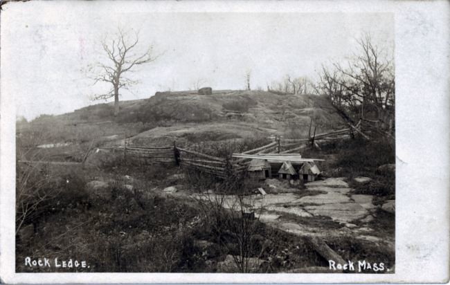
The rock ledge from which Rock, MA takes its name. Early 1900's postcard
Day Four: Seems there is no end to the heat of summer! With a hot day building before me, I decided to put in a short day before making my way home.
I had what I thought might be an alternate access to a site I visited last year outside of Plymouth where one - of two - possible "Devil's Rocks" might lay. My access road soon turned up as invalid and after checking out an access point to the local river, I moved on.
Better luck was to be had farther east in Plymouth County where a possible Indian mortar/grindstone was examined. For real - or not. One cannot say. But the day (and trip) was brought to a conclusion in the Village of Rock where after several visits, the location of the ledge (and old postcards) from which the village took its name was verified.