

This is the one I look forward to all year. The annual return to Essex County which has me staying out on Cape Ann. This year I had enough on the Cape to keep me busy but first...
Day One: Coming in by the standard, routine approach - Rt. 128 - I stopped in at one of my old favorites Ship Rock in southern Essex County. It is always a challenge to try to photograph this boulder because of it's enormousness size and generally I arrive during early day when the rock is drenched in sunlight. Moving on a bit to the southern perimeter of town I reexamined a patch of conservation land just littered with glacial boulders, some of significant size. One worthy specimen is a classic perched/balanced rock just over 60 feet in circumference. Last - before pulling out of town to set up camp - I ascended at ridge quite close to the town boundary where power lines had opened a path showing dozens upon dozens of perched boulders left from the glacial age. All this area was once the object of study of the Essex Institute - now merged with the Peabody Museum - during the middle 1800's.
Day Two: Some excellent Fall weather and I took to the most northern portions of Cape Ann. A local woman had provided clues to a couple possible caves in that area and searching coastal areas found a couple cave-like features formed in gigantic boulder piles. I later confirmed this as one of the caves mentioned to me by the local woman. I followed this with her second lead passing by old quarries (of which - many exist in this area) to a ravine I thought might be the cave location. With nothing seen here - I moved on.
The Devil's Den, along with Profile Rock
Down the coast is Pigeon Cove, the location of many old photographic and postcard images. Especially of rocky formations. One is the Devil's Den and Profile Rock. Success was to be had at locating this old site. Still further south lays a section of Gloucester once know as Joppa. A good chunk of woodlands was covered in another less than successful attempt at locating the Old Man of Joppa profile formation. After chowing down some bogus supermarket pizza, I decided to work off my meal in the southern extremes of Dogtown visiting Tent Rock and five of Babson's inscribed boulders.
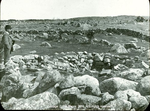
The expanse of Dogtown with Uncle Andrews Rock (aka: Babson's 'Spiritual Power' boulder) to the far upper right. From a 1890's glass slide by W. S. Beekman.
Day Three: Now we come to the Dogtown walk. Wouldn't be a visit to Cape Ann without one significant hike through the moorlands that once was the main settlement of Gloucester long before residents took to the coastal areas. Working with a newer publication I picked up late last year, I walked a unnamed trail down towards Babson Reservoir where my book told me rocks larger than Uncle Andrews and Peter's Pulpit - two of the largest erratics in Dogtown - might exist. Although numerous boulders were to be seen - some of pretty big size - I cannot say they exceeded the aforementioned rocks in size. But I made a circuit by coming back up the Babson Boulder Trail and verifying that the backside of Uncle Andrews Rock (aka: Spiritual Power) was the site represented on an old glass slide I picked up the preceding winter. Cellar hole #23 (stone seems to be missing) finally was located. This one belonging to Col. Pearce, a wealthy Gloucester family, and one I had an postcard of the old cellar hole.
To the northeast, near the Goose Cove Reservoir, another section of old Dogtown was investigated. One cellar hole marker on the road in was found, one on a rock in the Reservoir (visible only because of low water), and two were found along the city street leading away from the waters. Goose Cove has(had?) a small waterfall depicted on an old postcard. The site was located but with water running on the low side, did not appear particularly significant.
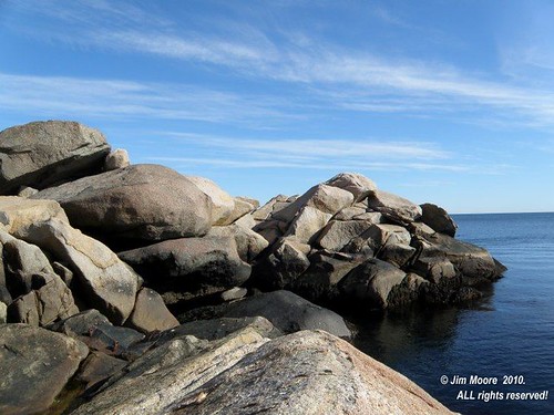
Once again shooting out to the northern extremes of Cape Ann, I further worked cave lead #2 from two days ago, weaving my way through many an old quarry, but still finding nothing noteworthy. Then out to the ocean side at two locations, at one - visiting Chapin's Gully and the Great Gargoyle.
Day Four: Down in the urban town is a patch of nature that survived and is known as the Magic Garden. Following my visit to the Garden, I returned to scour another section in Joppa coming across interesting boulders and ledges but no Old Man. Coming down the coast I decided to spend my final hours in town at sentimental favorites in George Washington's profile and Rafes Chasm Park. On the way back out of the area, I found my way to Singing Beach at Manchester looking over rocks at both ends of the beach. Postcards depict Eagle Head (shape of an eagle's head) and one of the Sentinel (rock). After experiencing the 'singing' of sand beneath my feet towards the beach's southern end, it was time to leave Cape Ann once again...
Addendum: The return home brought the usual sifting through, and going over, all that had been gathered. Additional research brought up some very interesting information on sites in the vicinity I had just covered near Ship Rock, et al. Long sought Wigwam Rock appears to have been mostly taken for construction purposes some years back. Still I would like to pinpoint its location. Lookout Rock, also once looked for, has showed up on a map with a pretty definitive location. And a new entry: Kimball Rock. All will be worked on during future visits to Essex County.