Starting off four days of beautiful weather was one of the eminent geologic features in all of Massachusetts: Purgatory Chasm. Although I have visited it several times in the past, my more specific goal was the location of a lengthy cave I call 'Fish Diet Cave' - or aka Damnation Cave. I took the opportunity to visit most of the major features in the Chasm and update photos on some of them. A couple of the smaller caves I have not visited in the past were also explored.
USGS file photo of pothole in the Blackstone Gorge
Unable to locate Fish Diet, I moved on to the mighty Blackstone Gorge where high waters made for an impressive site! Downstream from the Rolling Dam, the river eventually enters the George with high rock walls. One has been depicted in the past on a postcard as Lovers Leap. A massive boulder in the river is also known for the king-sized pothole that runs through it. Before leaving the Woonsocket area, I made a trip to look the Cold Spring which sits in a park by the same name.
The Cold Spring
A likely King Philip and H P Lovecraft site overlooking the Pond
Next up was Lincoln RI whose Lincoln Woods boulders are a favorite amongst climbers. I concentrated on northwest portions of the park where I wanted to take a stab at identifying an old photo as well as photographing a minor cave formation. In the nearby settlement of Lonsdale, the Indian Red Rock was given another look after many years to see if it could be matched to its old photo.
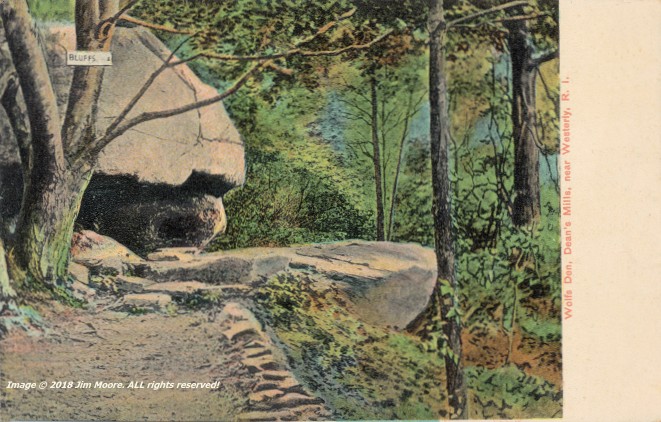
The Wolfs Den, as portrayed on an early 1900s postcard
Day Two started off by connecting with RI authority, Mike G., from whence we proceeded down into the southwest corner of Connecticut to take on Wolfs Den. Then it was all the way back up to northeastern Rhode Island to see Bigfoot Cave, the site of the mineral Cumberlandite (state rock of Rhode Island), and the possible site of an Indian encampment: Mollie's Bedroom.
At the main entrance to Bigfoot Cave
Leif's - or Norseman's - Rock
By the third day I was back traveling solo making an early morning excursion to Rocky Point Park. This was a relatively quick trip, seeing the shoreline, catching the image represented on an old postcard, and a stroll past the cave formations located nearby. Hopping across the upper end of Providence Harbor/Seekonk River, I was able to make a mid-morning low tide at Leif's/Norseman's Rock before returning northward to Massasoit's Spring.
King Philip's Cave (above) from an early 1900s postcard
King Philip's Cave - modern day
Back into Massachusetts, I took a quick look at conglomerate outcrops in the area of Luther Corner before going on down to Fall River at Creeping Rock. North again to King Philip's Cave and a look at future water access to someday visit Gary Rocks. Moving on to the Foxboro State Forest, I attempted to look up a letterbox, mostly because its description included the 'stone face'. This proved unsuccessful, so off I went to the Wrentham State Forest to Boulder Cave before retiring for the night.
Boulder Cave
The likely Cart and Oxen Rock
The fourth day was somewhat abbreviated doing more rocky formations in Wrentham, which included a likely success at finally locating Cart and Oxen Rock, a couple caves, and a giant rock pinnacle. From there, another quick run was made into Purgatory Chasm in a final attempt to locate the Fish Diet Cave. Once again - no luck. But maybe next time!
The Pinnacle
Onward home!