Friday, September 22, 2023

Thomas and Palmer Brook/Whale Rock


Another first for me was this Berkshire Natural Resources Council property in Great Barrington. It was a typical Friday morning hike with the Hilltown Hikers. Nice piece of land with an easy, level circuit trail through a meadow, and an ascending woodland trail that takes one near to the top of Three Mile Hill.

On the 'back' of the whale

At the terminus of the woodland trail is a ridge of rock carrying the name Whale Rock. I find the analogy somewhat of an exaggeration. Significant imagination is a requirement! Nonetheless, it is an interesting outcrop of rock and a nice climb upon the top.

Wednesday, September 20, 2023

Beyond Round Mountain


This trip was put together by South County's Gary L. Two other individuals joined us with one leading the way to some mysterious stone walls. We started at the trailhead for the McLennan Reservation at Round Mountain. This is a loop trail around the Mountain but we ascended by the easterly branch only.

Upon reaching the upper limits of the trail (the actual summit of Round Mountain has no trail) we diverged along a continuation of old Fenn Rd which was not always easy to follow and involved a number of detours through the forest. Numerous stone walls were present, usually with the road running between a set of two.

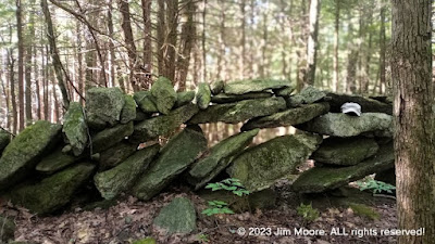
We eventually reached our destination where a good length of the stone wall was stacked in a rather unorthodox fahion. Instead of the usual tight, horizontal formation, these were sitting much more upright, often with large gaps between.

A mysterious piling of rocks

Still following the wall, we quickly arrived at a large wetland area through which ran a small brook. A small breached dam was also present, in line with the continuing stone wall. From here we moved on a bit north where the remains of a very large cellar hole was present.

It was then we retraced our path back towards Round Mountain and eventually down to parking at the trailhead.

Friday, September 15, 2023

Beulah Land


This hike took us in to parts of Blandford that show on certain old maps as Beulah Land. More modern maps carry over the name with Beulah Land Road. It does make a nice entrance to parts of the Chester-Blandford State Forest.

Antlers left near the summit of Green Hill

At one point we dove into the brush and woods searching for possible pond and building remains from long ago. Not much found here but the regrowth of forest that was once clearcut causing runoff to swell a beaver pond and burst its dam. Any building remains would have been on the far side of a large patch of wetlands at the former pond site.

Trudging onward, we eventually made our way up to the summit area of Green Hill. The summer growth along with downed trees made for a difficult going. But we were able to ascertain the approximate location of an old home. One of our goals was the location of a sulphur spring whose location is mentioned on a couple old maps.

Returing to the main road we quickly diverged into the woods on the opposite side looking for signs of a possiible old gold prospect. Little of a definitive nature presented itself so once again back to the main road. Finally we reached the site of a former CCC project which long ago was an old swimming hole. Not much remains that is recoignizable besides the old dam. It was decided to trace the source of the water to see if any connection with the sulphur spring might be had. Although the source was finally found uphill, it MAY have come from underground springs, but not quite the correct location for sulphur spring.

Thursday, September 14, 2023

Searching caves and mines...


Armed with a 'brand new' cave lead, I took to the north County. More specifically, the Savoy Mountain State Forest. Although my trip began in the town of Florida, hiking eventually took me over into North Adams. I kept my expectations low as I suspected the chances of finding much of a cave pretty slim. I was not surprised. Lying under the lip of a shelf of rock carrying a mountain stream lay the 'cave'. Apparently through the process of years of freezing and thawing, a portion of rock had moved forward leaving a cavity behind. Some erosion added to rounding out the semblance of a cave.

Cave formation under ledge with mountain stream

Returning to Savoy, I intended to explore the possibilities of a northern access to the old Little Egypt Lead Mine. It was an ill fated attempt as I did not prepare adequately on where to begin my hike. Some very nice woods on a beautiful Fall-like day but no mine. Another time.

Friday, September 8, 2023

The Westfield


This interesting jaunt along the Westfield River took place just inside town border for Westfield. Some call it Tekoa Narrows. But making our way down to the big River, we worked our way along the shoreline. Spotted was a mysterious old foundation build right into the sifde of the steep hillside. Certainly an abundance of rocks including one with a mysterios inscription which we are trying to deduce.

The mighty Westfield River along with the Mass Turnpike bridge

After reaching upstream, we reversed course following alongside the riverbank. Many interesting variety of trees present as eventually we made our way to the highway. There was one more dive into the riverfront propert ads we negotiated an old overgrown field with collapsed barn.

There was one more quick stop up the road at the parking for Tekoa Park's trailhead. Here we ascertained an old trail led down to the area of the foundation we previpously saw. A difficult and steep descent to be sure!