Friday, November 19, 2021

Tekoa!


Helping Mike finish this year's trip to Western Massachusetts, we met at an access point north of majestic Mt. Tekoa. The goal was to check the summit ridge for a reported cave, then continue the hike a ways towards English Grass Cave.

View from the summit ridge of Mt. Tekoa

Some prep work, along with modern GPS and mapping technology, made accessing the Tekoa Summit fairly easy. But along the way we quickly became aware of severe trail flooding with impoundments creating small ponds at certain points. After reaching the ridge that looks down on the Westfield River 900 feet below, we followed that ridge to the northwest to use the existing network of trails (along with a moderately long bushwhack) to eventually end up at English Grass Cave. A lot of walking and a lot of climbing involved. Upon our departure from the cave, it was one more lengthy walk and a bushwhack to skirt a pond covering the old woods road. Beat up and tired, we eventually reached our cars and said goodbye until our next adventure.

Mike extracting himself from English Grass Cave

Monday, November 15, 2021

Mike Does the Berkshires!


November came calling - and that is the time of the year that heralds the return of Mike, the Rhody Mountain Man. He had a well prepared list and we set of (after breakfast) to seek out something new for both of us: Kelly's Caves. The area was part of a favorite of mine, a small mountain in the foothills of Greylock known as Sugarloaf. The whole area is a 'sort of' karst area boasting 'caves' of different origins. There is some bona fide karst in the marble surrounding parts of its lower elevations and the section area we explored was an area I had never ventured onto.

Mike descends into one of Kelly's Caves

But Mike had some pretty good coordinates for the area we sought out and with a bit of bushwhacking, we eventually landed in an area of a sinking stream. Two small caves were to be found. But, in the end, fill made them somewhat short, . While Mike checked out the underground I roamed the forest seeking out evidence of further karst formations. This proved to be fruitless and soon we were headed on our way out of the woods.

Mike searches through the talus for Bear Cave

On our next stop, we sought out a somewhat vague mention of a cave up a steep hike in Williamstown. It basically was a geocache site in the Pine Cobble region, located among a tremendous slide of talus. The definitive site of that cave could not be totally confirmed after much searching. We moved along, then on to our prospective homes.

Friday, October 29, 2021

Chester quartz

One more hike with the Western Mass Hilltown Hikers and 'old' bud Tom (really - I'm older than Tom). This took us into Chester once again, one of the most heavily mined towns I've come across in Massachusetts. One of the group's members is owner of the land and was our host for the morning.

A boulder of interest.

The property is quite hilly (indeed, the access road was something to marvel at!) and we began an extended hike though woods with occasional views of Chester far below. A quartz quarry was the ultimate object of our walk and was the last thing we encountered. A deep open cut into the rocks, with partial collapse, was all that was left to see. Along with a few drill marks.

Exploring the interior of the quartz (rock cut) quarry.

We pondered what quartz might have been used for. It was during my later 'debriefing' it apparently went into the manufacturing of porcelain. Chester even had (at one time) a manufacturing operation that made use of the local quarried quartz. And Chester, long known for it's emery, did indeed have numerous quartz quarries.

Sunday, October 17, 2021

Byrant!


Sometimes it's nice to 'kick back' a bit and do something that leans more towards the recreational rather than the many, much more, intense excursions I find myself on. On this nice Fall day, I rode into Cummington. A town I've traveled through oh so many more times than I could remember. It is often on my main route to and from the Berkshires. The destination? A place (believe it or not) I had never visited: the William Cullen Bryant Homestead. A Trustees of Reservations property.

Under the forest canopy!

Today's walk was lead by naturalist Aimee Gelinas of Tamarack Hollow in Windsor. It was the quintessential hike through sylvanian wilderness that encompassed learning opportunities on a variety of subjects. Subjects such as tress, fungi, and even a smattering of geology. For those wishing to follow our route, it took us down the Rivulet Trail. Near it's farthest point, we diverged onto the Pine Loop which did bring us back to the Rivulet and our way from the forest. Picturesque all the way!

A fine specimen!

Thursday, October 7, 2021

Just over the Line.

A wet insurgence entrance to Merlin's Cave

This trip was focused on just over the border into New York State. Here liesproperty of the Notheastern Cave Conservancy. Two nice caves, Dragon Bones and Merlin's, may be found. But both are closed to human exploration during the winter mortoriuum to protect the bat population. However, Merlin's is considered a very challenging cave and beyond the capibilities of the two old seniors hiking about the preserve.

The twin tunnels. Left one abandoned

Adjacent to this cave preserve is a set of twin railroad tunnels. The more northern of the two, is the oldest being constructed about 1840. It is now abandoned but the southern one (built in 1912) still sees use.

Thursday, September 23, 2021

The Other Cape!

One of the balanced rocks @ Franklin Park - early 1900s postcard

More and more in recent years, I've been known to say aging may be the last, great experiment in one's lifetime. As a bona fide senior I find it sometimes goes well. Other times not! And so it was on a traditional late summer/ fall trip up into Essex County. For the most part it was devoted to Cape Ann, celebrating 20 year ago I first landed at the local campground. But in the end, for whatever reason, the overall trip had to be devoted to a lighter set of activities.

Part of the Ruins. Boulder with Emerson plaque.

My goal on the first day was to put time in at Franklin Park defining the locations of it's many boulders, particularly in the Wilderness section. But first was a social call on the edge of Newton to have coffee with a friend from recent years. By the time I reached Franklin Park, it was a busy Saturday with activities going on. I got in a nice trip to locate someof the boulders, check out possible locations for Sunset Rock, then it was over to the ruins at the Overlook. That about shot the major portion of the day leaving much more to be done in the future. From here it was onward to Cape Ann!

Small sea cave formation around 1888

The winds were blowing a gale on the second day, so further testing on the new kayak was put on hold. I did make the 'tour' around the coastal areas, looking into Lanes Cove, Folly Cove before landing at Halibut Point. A lot of good hiking at Halibut but the pathways going down towards the ocean get to be a bit more strenuous. After finish up at Halibut it was off to one of my favorite all time places: the Atlantic Path of Pigeon Cove. An assortment of rocky formations lie here and I did visit several including Singers Rock and Chapin's Gully. Then a walk along the road just off the rocks (and a quick 'dive' into Andrews Woods) brought me by some rock sculptures upon a private lot. Next in line was the Town of Rockport bustling with tourist activity. I used this visit to locate any possible downtown access points to the ocean. I finished Rockport at the Headlands then it was off to the Magnolia section of Gloucester. Here I explored the Shore Rd area which included the Great Stone Face/Lady of Rock. The day ended at Good Harbor Beach where low tide enabled me to see the passage over to Salt Island and the tiny sea cave opposite that island.

How the old Coggeshall Camp looks today - from the ocean!

Some of the cliffs that line Folly Cove - early 1900s postcard

The morning of my third day was intriguing to say the least. I had a lead of an Indian Rock within the Gloucester boundaries. At one time long ago, it was a big time party spot for the local youngsters. Almost a local legend, it seems no one had been out to visit it in recent years. But with a few directions I made my way into a 'secluded' spot tucked in between sections of neighborhoods. Some development had encroached upon the purported location so it had to be determined if it still might exist! Well, it does not take long for Mother Nature to reclaim land that gets little use. I almost literally had to claw my way through dense overgrowth that was a lot of briers and sumac. By the time I exited this mess, I left disappointed and unsuccessful! But of a more relaxing nature was a cruise out of Lanes Cove, putting the new kayak through it's paces on the open ocean. Sites passed as I head north were the location of old Coggeshall Camp and Folly Cove.

Rocks towards the end of Cressy Beach - including the sea serpent!

Day four brought me off Cape Ann as I planned to do some exploring around Marblehead. I started off in one of their very old cemeteries. Then I left the mainland behind to head over to the Neck. Big time favorite Castle Rock was my destination but I just missed low tide and access to the small sea cave in the area. But I set up and grabbed a number of good photos of the old Rock itself before exiting Town. Back in Gloucester, I used the opportunity to visit Stage Fort Park and it's beaches: Cressy and Half Moon. Before landing back at my campsite I went up the road to Wingaersheek Beach where low tide was prevailing.

Entrance to small cave in Dogtown

On Day #5 I wanted to make one more trip up to a favorite location on the shores of Pigeon Cove. On the way, I visited the Granite Pier, and the Pigeon Cove Breakwater. Then it was back out onto the rocks that I've spent 20 years enjoying. With that behind me I had to make at least one small trip into Dogtown. The choice was the two caves first visited some years back.

Indian Rock - found!

Pulling camp on the morning of the sixth day, it was a decision on "what to do?" before leaving Town. I had been in touch with one of the local people over Indian Rock, with a little more information provided. But did I want to brave the 'forest' that tore me up badly a few days earlier? Ultimately, I said yes and on my way I went. Taking it slowly - and altering my course slightly - once again I was enveloped in sumac and briers. I eventually spied some painted surface and made my way over to it where I was rewarded! Indian Rock at last! It was so completely surrounded by growth you could not get back enough for photo. But signs of the past were present including old beers cans and broken glass - and lots of old paint upon the rock. Extracting myself from a messy situation, I accessed the car, caught Rt 128 out of Town and made my way to the Mohawk Trail and back to the Berkshires.

Thursday, August 12, 2021

South Shore Environs.


After several years absence, precipitated by hurricane winds and the difficulties Covid presented, I was finally able to land once again in the South Shore region of the Bay State. Little did I expect that heat and a banner year for bugs would make for a rather challenging situation. BUT there was excitement surrounding this trip: a chance to try out a new modular kayak. One that would herald my return to the ocean for perhaps the first time since 2015!

But before landing in that Land south of Boston, I had some sites to pick up in Sherborn. So dropping off the turnpike in the Framingham area, I wound to the south, arriving at Peter's Hill. Peter's was visited many years ago in a search for the Devil's Cartway. I expanded that search of the Hill, eventually climbing its southern end, coming across its summit area and then down the northern end. Although one site at the bottom - and one up above - provided a 'rift' (or possible 'cartway') in the hillside, neither one really grabbed me as being very pronounced. Other references I have for the area included the Indian Head Quarry, Devil's Oven, and a 'salt-peter' operation. Just over 2 milkes to the SSE of Peter's was some conservation land containing a nifty balance rock - or the Sphinx, as it is sometimes called. My time in Sherborn was finished with some hiking out to King Philip's Overlook above the Charles River. Here the bugs and I battled for supremacy and eventually I had to yield to their superior numbers. I jogged to the north to the area of the Pike (in fact going under it) to search for an Indian Head and Leaning Rock, the latter once visited by Henry David Thoreau. It was mostly a residential neighborhood with no one about. There is a local camp where I was told they could not accept visitors due to Covid (no word on the Indian Head and Leaning Rock). Then it was on to the Wompatuck State Park at Hingham.

Boulder near the weir

The Devil's Cave

The second day, after a long rainy night, took me farther south into explorations of Plymouth County. Included in these rambles were a fish weir and giant boulder, a cave report (nada here), a 'Devil's Cave' (split rock) along an old rail trail, site of a Colonial 'tea party' (tea burning), and searching out a second cave report. I kind of knew from additional information, this second reported cave might really be an old tomb. And it was! Brant Rock was nearby but upon getting over there, I found the tide well 'in' and masking most of the usual shoreline rocks. So I finished this day by going up the coast to Cohasset and looking over any possibility of access to Little Harbor. This has stymied me for many years and still seems to present an unlikely opportunity.

Doherty's Rock

Started off day three by riding out to Hingham Harbor. I kinda knew the tide was far from high, and a quick check confirmed this would not be the best of times for kayak launching. So I rolled down the coast to do some photography work in Scituate. It had been years since seeing some of these rocks so out came the more modern cameras. First was Hatchet Rock followed the Nubian Head Rock at the harbor area. I stopped for a short spell to see if the local walking group might show as their previous day's hike was canceled by the rain. No luck here. So it was off to Doherty's Rock (along the way, I saw the massive Damon's Rock through a back yard) and coffee at the local java bar. By that time, Hingham Harbor had filled to a much higher level and it was time to roll out the touring kayak! A delightful four hours - or so - touring in the bay, visiting the islands, and finally going over to the east side of World's End. The kayak performed as expected and now a new chapter begins in my water exploring adventures!

Conglomerate rock on Hingham Harbor island

On day number 4, the searing heat brought my trip to an eventual end. I went out on the Gulf, along the Scituate-Cohasset border, but being at mid tide, it did present it's problems. Also, the strength in my arms was drawn down from the long outing of the previous day. Even so, I did make it as far as Lion's Head (the likely Buck Rock in the Town's history) before my limp arms returned me to the put in. Unfortunately, Landing Rock, on a side stream, had to be left out on this trip. Bathed in sweat, and arms that could barely gather up the folding kayak, I returned to my campsite to break camp and brave the Boston area traffic home.

The Lion's Head - on the Gulf

Saturday, August 7, 2021

Mine all Mine


Another opportunity to join the Western Mass Hilltown Hikers, and 'old' hiking partner Tom, for further explorations in the Town of Chester. Chester has repeatedly provided an abundance of history and geology over my many years. So always great to get back there again. The goals on this trip were the Melvin and Wright Mines.

Approaching from the south, it was a bit of a hike in but our first objective, the Wright Mine, we eventually located after following old roads, crossing a stream and a bit of bushwhacking. Wright was an open cut with some water in the bottom. It could be carefully traversed with the aid of some (slippery) logs. Ascending out the far end provided a mild challenge.

The old Melvin Mine

Making our way further north, a bit of hunting was necessary to bring us to the Melvin Mine. Along the way, a couple filled pits and remnants of other old mining features were encountered. Melvin was a much more spacious open cut who's bottom was mostly covered with a good amount of water. After photos, and exploring what we could, the Hilltown Hikers retraced their route back while Tom and I cut across the countryside. A small quartz quarry was encountered along the way before emerging from the woods and locating our car.

Thursday, July 29, 2021

Shadows of Hitchcock


At Titan's Piazza

The year was 2004 when I descended upon the Hadley area to search out formations written about by eminent geologist Edward Hitchcock and others. That trip covered the Mount Holyoke area and Warner Mountain. I hoped to at least partially recreate that trip - and maybe even kayak out into the Connecticut River. But in the end it was shortened by approaching rain.

The Devil's Football/The Magnet as depicted on an early era postcard

However, I did get up to Titan's Piazza with my assemblage of cameras. That was followed by a leisurely drive to Mt. Holyoke's summit and exploration of the exposed rock outcrops. On the way back down, a quick trip was made to the Devil's Football. Or as Hitchcock called it: The Magnet.

Saturday, June 19, 2021


I was afforded the opportunity to join an old friend and we both met the Western Mass Hilltown Hikers. Today's hike was to look for signs of quarrying history in Hampden County around the area of the Little River. At least one of these quarries went by the name of the Atwater Quarry with serpentine marble being its specialty. This is also the area of a Native American soapstone site.

The old quarry

A bit of searching along old routes did eventually lead us to a splendid old quarry that was high above the Little River. (Years ago, I had visited a companion quarry across the river to the north and the hiking group took this on after we parted ways that day.) After exploring the aforementioned quarry we attempted to trace the route of transportation line steeply down - and across - the Little River. Bridge abutments still stand marking this route. We also located sites of an old shop and mill once we forded the river.

Abutment to the crossing of the Little River

Mission basically accomplished, we hike back out to our cars and said our goodbyes.

Thursday, June 17, 2021

Boulders, boulders everywhere. But not a cave to be!

Earlier in the season I made a somewhat crude attempt at relocating Hunters Cave north of the Greylock Glen area. Things have changed considerably (my memory included) since those days long ago when I last visited. Preparing a bit better I made another stab at it!

This trip relied heavily on GPS coordinates supplied from a list by long ago area explorer Alan R. Plante. The coordinates were located after pushing along trails - some totally overgrown by ground vegetation. Ledges and many boulders were found, none of which I recognized. After giving the area surrounding the coordinates a thorough going over, I aborted in favor of returning on another day. Perhaps without foliage!

Sunday, May 23, 2021

Back to Essex

Ancient land boundary

Twenty months is a long time to be away from something that has been my 'old stomping grounds' for a couple decades. Between Covid and late summer medical, that's what happened during 2020. So it was with keen anticipation I took to the road and looked forward to landing on Cape Ann once again.

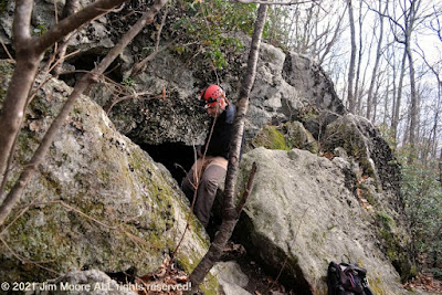
Small cave formation @ Den Rock

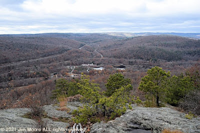
But before that could happen, I wanted to check in at several sites not visted in a VERY long time! First up was an ancient land boundary boulder in northernmost Essex County. I see that over the last dozen years it had lost the picturesque tree that once grew alongside it. On to Den Rock where it once was reported the Devil resided in its trademark fissure in the ledge. Over the years I've picked up couple interesting photos. One definitely showing the well known rock face, the other: unidentified but likely can be traced to this site. Down in the region of the Harold Parker State Forest, I did trace two very old photographs to the Jenkins Boulder (which I had identified from a 2000 photo of my own doing) and visited the old Jenkins soapstone quarry by way of a new access I recently discovered. The day was finished with further testing of the fold-able kayak on the Annisquam River.

Originally labeled as Cape Ann - circa 1880s...

...Today known as the Jenkins Boulder in Andover

Day two turned into a real treat! I was taken on a tour of some difficult to access local sites including quarries and private estates. These are areas I would have never seen without the company of my host and local gardener. I saw several Lanesville area quarries, an old cemetery (where the namesake Lane Family might be found) and estates over in the Annisquam section of town. I got a real lesson on how gardens can work to complement the rocky surfaces that are a typical part of Cape Ann. Along the way I was treated to Sheep Rock and the possible discovery of Tilting Rock. Upon parting ways with my guide, I traveled up and around the top of Cape Ann, stopping at Folly Cove to search out the whale that had washed up there weeks ago.

Tilting Rock as it appeared circa 1880s...
...the likely Tilting Rock as it is today!

The third day took me up to Newbury. I hoped to find possible access to the Parker River from an island on the Great Meadows property. Although this did not prove to be a reality, I took the time to look over several large boulders at that location. Some have said one of them is Gerrish Rock. My very knowledgeable local source took me there years ago to show me Gerrish Rock rising from the Parker at low tide. It's not often I get into Newbury so I went over to the Devil's Basin (old lime pit) along with the Haystack Boulder and another one off in the brush simply identified during the 1890s as 'a glacial erratic boulder of quartz augite diorite' . On the way out of town, my day was cut short with a flat tire . Phooey!

Glacial boulder @ Great Meadows
The Devil's Basin

Day four came and it was time to make my way to one of my most favorite of all places: Pigeon Cove. But first stop was closer to Rockport Center at Old Garden Beach. I had to photograph the large boulder first seen many years ago and told that it had a name: which, of course, I long ago forgot! From there it was on to the Atlantic Path which allows me access to the Atlantic shoreline and many of my favorite rocky formations. Here I was 'reunited' with the 'Meditation Seat', Pulpit Rock/Singers Rock/Dianah's Bath, Chapin's Gully, the Great Gargoyle, and Metoric Stone. Old maps of the coastline list archaic names to many of these places and at some future point I will explore than further. Coming just off the coastline, I looked to see if the site of an old chalybeate spring could be found. From the plant growth, one area looked to be excessively damp, but nothing definite. I then took a quick look at the overgrown Profile Rock and saw that it would eventually need a small cleanup to free it from the dense overgrowth. A bit to the south, I came to the Turtle Mound and old Rockport Hospital ruins. A quarried boulder lay secluded just out of site, buried within the underbrush.

Dianah's Bath - with Singers Rock in the background. Circa 1870s

On day number 5, I left the Cape to travel down to Salem. I'd seen a number of postings on some conservation land in the area known as Salem Woods at Highland Park. I did a quick one hour trip around its perimeter that gave me a good idea of what it offered. Forests, marshes and meadow lands with enough rock outcrops to tell me what might lie beneath. Leaving Salem behind, I took a jaunt roughly northwest for twenty miles to continue on from where I left off the day of the flat tire. This covered the Stickney Boulder, a search for a memorial boulder with plaque (a no show) and ending at Holmes Rock, another old land boundary.

The Stickney Boulder
Holmes Rock

I noticed the return to longer trips proved fatiguing. Either out of shape or just the normal aging process, time will tell. So on the morning of the sixth day, I pulled camp and set a direct route home to the Berkshires.

Wednesday, May 12, 2021

To Blackstone and Beyond!


Ah springtime in the outdoors! With the black flies feasting away, and my allergies raging away, it was time to make my first overnighter since 2019. The destination: deep into Worcester County. The goal: to start with a lead hanging about from late last year.

When my outdoor season was abruptly ended due to medical concerns late in the summer of 2020, I left a tantalizing clue to the mystery of a House Rock within the Blackstone Valley. A piece of conservation land with that name might be the answer to the mention of such a formation in the town's history. Slipping into the property, which is barely 3.5 acres and surrounded by housing development, I began my search. Barely a rock could be found! I returned to the suburban streets to canvass the neighborhood I had been through 5 years previously. Finally after checking other nearby conservation land and neighborhood streets, success of a sort. Buried behind the corner of a house, and for all intentional purposes inaccessible, was a gigantic monolith of rock. With no one at home, I had to leave my find behind and move on.

Beehive stone chamber entrance

Next town east found me following the report of a boulder near housing along a quaint little lake. This boulder did not show itself so I ran over to the nearby beehive stone chamber to update my photos.

Slipping (just barely) into Norfolk County I connected with local author Marjorie Turner Hollman who puts out a series of guides to 'Easy Walks' for people of more limited abilities. Together we explored an old trolley route in her neighborhood.

Abutments to former bridge and trolley route

Nicking the corner of Middlesex County, I put in an effort to locate Jasper Rock. My information was really scant and I wasn't even sure what I might be looking for. Having a starting location, I went through a large tract of woods. A couple of erratics were there and a hilltop with a water tank on it. Could this be the Jasper Rock site? My debriefing later that afternoon confirmed I did not locate it (recognize it?) but I gleaned enough to make another competent search in the future.

Devil's Pulpit (aka Pulpit Rock) as it appeared circa 1870s

The following morning found me a bit north of Worcester itself checking back into some minor caves first visited ten years ago. While in the area, I wanted to check a 'new' access into the Devil's Pulpit and nearby Half House Rock. This route makes for a bit shorter journey than what I've used in the past. Since it was obvious by then I had one more walk left in me, I went ahead in to update photos of Devil's Pulpit and Half House. Then it was only to find my way to the Mohawk Trail and back to the Berkshires.

Wednesday, April 28, 2021

Hiram, Leaning, and the Oven...


Hiram's Tomb long ago. Unknown date but likely circa 1890

The primary goal on this trip was to be testing the assembly of new kayaking equipment - in the field. I had already gone through the learning process at home and was anxious to further that skill. Also to try out the handling of that new equipment in a real-life situation. That did not happen as I was looking for a somewhat private place far from the gaze of onlookers. And the location I chose down in Chester Ma proved to be a busy location.

Hiram's Tomb as it is today!

But on the way into town, I thought it worthwhile to check into one of my favorite locations at Hiram's Tomb. After all, it had been almost 12 years since the last visit. The location and hike in went smoothly and it allowed for some much-needed update on my photos. Afterward, I made my attempt on Littleville Lake before moving on to the Knightville Dam in Huntington. Much like the lake at Littleville, Knightville is also the site of an Army Corps project. However, directly in front of the Dam is Leaning Rock (aka The Devil's Arm Chair).

The Leaning Rock as it appeared in the early 1900s

... and the Leaning Rock today!

Once again, I used the opportunity to do a photo update. It was the same day in 2009 when I last visited Hiram's and the Leaning Rock. Taking the scenic route back towards Windsor and Rt. 9, I made a stop at the Indian Oven. I had only one old photo from the end of 1999, so a good chance to update that as well.

Indian oven - as it appeared in an early 1900s postcard image

Sunday, April 11, 2021

'Coordinating' with a Tory

Tory Cave - or what's left to it

Sometime in the past, Rhody Mountain Man (occasionally known as Mike) had visited the historic Tory Cave alongside Roaring Brook in Lenox. But doubting his observations, he requested coordinates for the sake of comparison. Coordinates, I unfortunately did not have. Being a beautiful spring morning, I decided to pay Tory Cave a visit. Looks to be late in 1998 since my last visit. Coordinates and photographs obtained, I hiked on out of the October Mountain State Forest to enjoy the rest of my Sunday morning.

Wednesday, April 7, 2021

Old Friends and Railroad Lines


Reuniting with a long-ago hiking partner (second half of the 1990s), we had a chance to share one more adventure. Beginning in the southeastern regions of Berkshire County, and just barely in Hampden County, we attempted to trace an old railroad line. That line brought granite from the Becket quarry down into adjacent Chester where it was finished.

Collapsed road crossing of brook

Accessing the site of the old right-of-way began near the abutment of a former trestle. Getting in proved to be a bit tricky but soon we were on our way along old paths and Walker Brook. As we got deeper into the woods - and higher in elevation - we began to close in on Quarry Road. Here, the ROW eventually disappeared but sections of old Mitchell Rd. could be found including former bridges that once traversed ravines sporting attractive falls.

Culvert under old roadway

Eventually, it became necessary to bushwack on up alongside the stream, finally making our way out to Quarry Rd. On the opposite side, a woods road was located. It provided a southerly route, parallel to Quarry Rd, with old relics such as culverts (one being a small keystone bridge) and an old, primitive shed with ancient apparatus within. We finally reached the quarry parking lot where we had left one car. So it was only to drive back to car #2, where a brief examination of the trestle abutment ensued, then on to our respective homes.