Sunday, June 21, 2009

Origins


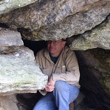
Father Stan

Father Stan (L) poses at a central Berkshire cave entrance


Oh well - a somewhat belated summer has finally arrived. Heat, humidity, bugs - although the ticks have been roaming about since late winter and are now biting in monstrous proportions. A somewhat strange weather pattern persists that does not give many days a break from some sort of rain.

However around this time of year many, MANY years ago it all began for me. I remember being in the midst of collecting comic books which have become quite the collectible in more recent decades. Issues placing the origin of certain characters ranking high as a collectible. So for the occasional traveler through this site (personal acquaintances know my story well) here is my "origin".

Obviously it begins with parents but beyond the biology was a Father. Stan was a well know cave explorer out of western Massachusetts. A learner to Clay Perry famous for his books on caves in New England and New York. Being the youngest of four children (all sons) I had patiently waited for my own turn to visit the stygian underworld I'd heard so much about.

It all began just to our north in an old marble quarry dating back to the mid 1800's. The sense of excitement at approaching the quarry's edge, and peering down in, will always remain with me. There - a small slot provided entrance to Baker's Quarry Cave. Although I can't say I saw my future flash before me, I definitely knew something special was beginning. More than providing entrance to a natural tunnel thousands of years old, I was gaining entrance to a unique world where geology and history intersected.

Although there is much more to the tale, this makes for a fitting story of one's Father - for Father's Day. So long after his demise, Stan travels with me each and every time I head on out.

Explorer @ Baker's Quarry Cave entrance, Berkshire Co

Another generation waits her turn at the entrance to
Baker's Quarry Cave

Saturday, June 6, 2009

Indian Rock, Worcester Co

Indian Rock


On this day I ventured over to the far (eastern) side of the Quabbin Reservoir to join with the East Quabbin Land Trust. Here, they have an ongoing project to bring Indian Rock out of the woods where it has lain for probably the better part of the past three decades. A trail was begun the day of my October 2007 visit, and that trail needed maintenance work, particularly after a winter that was cruel to the area woodlands. The ridge that the rock rests upon once sported a fine view, especially eastward. It is the hope of the EQLT to once again make that view possible.

Wednesday, June 3, 2009

The Pinnacle, Norfolk Co

The Pinnacle


This adventure begins where I began my April vacation - on Massachusetts State Forest land, just above the Rhode Island border. Taking on a different section of the Forest from where Boulder Cave lay, I returned to two small but interesting cave formations. The first would barely be human sized but has a smooth, worn passage somewhat reminiscent of a solution cave but likely is not its origin. Right nearby is 'another' boulder cave (this whole area of State Forest land is replete with glacial erratics)but with a definite 'passage' underneath. Here we have a huge boulder with just the right dimensions, setting down on a ledge, providing the small cave underneath. Also nearby is, what I have named, the Pinnacle, a giant spear of rock standing straight up at least 20 feet high. A casual look seems that a large, somewhat flat, erratic was left standing on what was previously its side. After clearing out of State Forest property, I took one more look for the cave formation in town that I failed to find back in April. This time it was a success and it lay amongst the red and purplish rocks indicative of (what is now mapped as)the Blackstone Group in these parts.

Working my way south adjacent to the Rhode island Border, I visited a splendid balanced erratic and 'boulder den' (cave-like formation) within a local park. More of the reddish rock was present on the face of the Den (it might be noted that a nearby area is documented for an occurence of red limestone). Turning east away from Rhode Island, I cruised on into a town holding a superb example of the Devil's Footprint formation. This set of footprints comes complete with story of a local man and his pact with Satan. Finishing out my day on the other side of town was one of the several King Philip's caves scattered around Massachusetts. Heading down deep into southeast Massachusetts I found my campground closed but a quick phone call confirmed sites available at another State Forest farther down towards Buzzards Bay.

Minister's Rock, Plymouth Co

Minister's Rock: early 1900's


Sliding Rock, Bristol Co

Sliding Rock: early 1900's


Day Two was to be primarily coastal towns starting in the western Buzzards Bay region and heading west from there. My first stop: Minister's (occasionally: Pulpit) Rock. Also seen in town: a split rock formation that made at least several appearances on early era postcards. I had been told by the landowner on a previous visit, Calvin Coolidge and Warren Harding posed by this boulder for a photograph long ago. In the next town west I drove by a giant pair of rocks visited on a previous trip know variously as Great Rock, Split Rock, and even Big Rocks but my investigation took me nearby to another reported "Great Rock". Located on a local golf course, I was graciously granted a tour of the surroundings, including the rock which they call Split Rock - yes, another! Afterwards, a direct line was made south to the coast in search of the Sentinel, a rock sitting off the shoreline portrayed on another old postcard. One more town west and a look for two features mentioned in local history writings: Leanto Rock and a Devil's Footprint. A thorough search revealed nothing definitive on these reported ahoreline area features. It is not usual for seaside rocks to have shallow, cup-like depressions and to say one is the footprint without further knowledge would be impossible.

I decided to bypass a few things on my list and continue directly west to Fall River where Sliding Rock lay waiting in a local park. While in town, a long overdue return to the famed Rolling Rock (one historical reference: Goose-nesting Rock) which is now the "official glacial rock" for the State of Massachusetts. Just outside of town, I stopped to visit an old friend/eBay dealer and great source of information on the local area. Nearby: an alternate access route was scouted to another King Philip's cave. On the way back to camp, I did a drive by check for a route to Joe's Rock and finished the day at the local library.


The rock ledge from which Rock, MA takes its name.

Early 1900's postcard


On a somewhat abbreviated third day, I journeyed up the Rt 495 corridor to investigate the origins of the Town of Rock (got to love that name). Along the way, a trail was discovered on land trust property that covers roughly the area that lends the Town its name. An old quarry site (and modest example of a 'footprint' formation) were present. I believe the location was found for a couple old postcards but will have to work this a bit more for further confirmation. I finished the morning, before heading home, in a neighboring town looking for a couple Indian ovens (rock formations) but a lack of definitive information made them impossible to locate. However, I did leave town with knowledge of possible contacts that may help. Location information can often be a long process.

Monday, May 25, 2009

Table Rock, Connecticut River Valley

Table Rock: circa 1870


On this excursion into the Connecticut River Valley the goals were more hiking and historic rather than geologic, although the latter is most always inescapably tied in to all I do. Making my way up the old mountain road, I set off to search for Paradise and the Garden of Eden. These names were very much tied to a section of mountain terrain and already in use by the late 1860's where I came across the first written reference. My journey took me over old Kellogg Hill (another archaic name) to one of the Valley's finest vistas - or "prospect" as they use to say. At one site I passed at least a half dozen conglomerate erratics - not native to this immediate area - strewn about as if it were the playground of the Gods - perhaps the Titans. One boulder carried the weight of two trees growing upon its top surface. This whole are is set back above a magnificent escarpment with Paradise - and its beautiful ravine - being it's northern boundary. Finally turning back - and upward - I climbed up into a commanding length of conglomerate ledge where one Giant's face of stone peered down upon me. Making my way the mountainside to my car I regrouped to head into the Garden of Eden. Also setback from a lengthy escarpment the old site likely existed with in cirque - or corrie - several of which exist in this area carved out by the glaciers of long ago. Eventually I passed an outlook with an old survey station marker and reached a spring fed swamp located within the top portion of a double cirque. The outlet for this marvel of nature is a stream that leaps over the escarpment forming a superb cascade. On the return to my car, I did some checking into the walls of the cirques where a partially buried stone wall spoke of times long ago forgotten. The way home - I took the lazy man's approach to Sugarloaf whose road is now open for the season. King Philip's Seat/Lookout, or Table/Jutting Rock as it is sometimes know, has been fenced off for years and views of it mostly hidden by foliage.

Sunday, May 17, 2009

Pulpit Rock, Berkshire Co

Underneath Pulpit Rock

Some of my very best times do not involve a rock - or a cave - or even being outdoors. On one marginal weather day I had the pleasure of meeting the family at a local farm in the central Berkshires to talk over the history of (one of many) Pulpit Rock. Although it never was ascertained if this rock was preached from by a real clergyman, the conversation went on to talk of many sites and bits of history throughout western Massachusetts. Nearby is a (previously unknown) quarry that provided stone to the building of two local churches. I will revisit Pulpit Rock and its caves at a future date for further investigation.

On the way to, I tried my hand at photographing Tory Cave but the stream it lays upon was much too high to cross. In the process I hiked on up through what has sometimes been called Tory Glen. A beautiful example of sylvan wilderness.

Sunday, May 3, 2009

The Bear's Den, Upper Connecticut River Valley, MA

The Bear's Den


For me personally, I have two significant reminders regarding the outdoors during early May: black flies and allergies. With inclement weather rolling around New England, I set out to see just how far I could get on a somewhat gray day. Heading up north to meet with the Mohawk Trail, I then continued my journey a bit farther north ending up at Pelham Brook about 5 miles south of the border with Vermont. The Stone Face/Profile Rock was my goal and I hoped to solve its mystery once and for all. A number of visits to this area, including the local historical society, have been made and finally last Fall a likely candidate was found in a stream side boulder. The first problem (after locating it) are the two postcards depicting it are quite different. Sure, certain shapes and striations on the rock are similar, but that's about it. The rock I gave careful examination to has some similarities with the two images but not enough for me to say definitely this is it. So it seems it will have to remain the likely Stone Face/Profile Rock.

On the return to the Mohawk Trail, I quickly looked into an old copper mine then headed on east into the northern portions of the Connecticut River (or - Pioneer) Valley. Turning north once again, I ended up at the Bear's Den, this time less than a mile south of Vermont. This is an ongoing project to revisit some old sites around northern Franklin County that haven't been seen in a few years and update my information. Bear's Den is formed in argillites where the bedding plane is tipped nearly vertical. Weathering has taken out a significant mass of rock making for a large chamber in the hillside.

Working my way farther south, I ended up again in the location where I've been researching the history of local rock formations in the Connecticut River Valley region. I proceeded to investigate the new set of ledges discovered on my last visit a week and a half earlier. Some natural chimneys, along with very small gravity slide and weathered out shelter caves were found. I've been looking over ledges one by one to see if I can find a match with historical data. On this day, I looked into another nearby ledge in search for "Warner's Ledge", but once again I came up empty handed. Nearby was Etta's Nook, so with the rain beginning to fall, I wandered on in to shoot a quick set of photos for my HDR (High Dynamic Range) project. Castle End is the gateway to this set of ledges and on my way out I did photos for a panoramic picture.

Sunday, April 26, 2009

Cross Rock, Berkshire Co

Cross Rock


Balance Rock, Berkshire Co

Balance Rock


Dabbling in the area of HDR photography, I ventured out to my favorite old proving grounds at the Balance Rock State Park. Here one can find an assortment of old relics in Cross Rock, Split Rock, as well as one of the Northeast's best know perched erratics in Balance Rock. Although the jury is still out on how useful HDR may be in my own projects, it can produce some 'lush' results. In the end - it still comes down to lighting.