Thursday, April 26, 2018

Success!


Ah how sweet it is. Success! Several years ago a couple of old postcards (reputed to be the same location) came to my attention. Along with (one of) Great Barrington's finest, we attempted to track down this site. Several failures were encountered along the way until an internet discussion brought valuable clues. So finally with Spring here, we set off with great hopes to finally visit Tramp Rock, possibly known as Weary Willy's Haven of Refuge.


Tramp Rock, as seen in modern days.

Access proved to be a bit tricky as I had to wade a swift current across a somewhat deep river. But just inside the woods, on the opposite shore, the prize was waiting! A massive glacial boulder surrounded by many other smaller ones. The story here is that it may have been a hobo camp long ago when a nearby railroad line ran through these parts.


Tramp Rock from an early 1900s postcard

An added 'bonus' to the trip were visits to several other nearby sites including Point of Rocks, Cemetery Ledge, and the old Beckley (iron) Furnace.

Tuesday, April 24, 2018

Tri-State Romp


Starting off four days of beautiful weather was one of the eminent geologic features in all of Massachusetts: Purgatory Chasm. Although I have visited it several times in the past, my more specific goal was the location of a lengthy cave I call 'Fish Diet Cave' - or aka Damnation Cave. I took the opportunity to visit most of the major features in the Chasm and update photos on some of them. A couple of the smaller caves I have not visited in the past were also explored.


USGS file photo of pothole in the Blackstone Gorge

Unable to locate Fish Diet, I moved on to the mighty Blackstone Gorge where high waters made for an impressive site! Downstream from the Rolling Dam, the river eventually enters the George with high rock walls. One has been depicted in the past on a postcard as Lovers Leap. A massive boulder in the river is also known for the king-sized pothole that runs through it. Before leaving the Woonsocket area, I made a trip to look the Cold Spring which sits in a park by the same name.


The Cold Spring


A likely King Philip and H P Lovecraft site overlooking the Pond

Next up was Lincoln RI whose Lincoln Woods boulders are a favorite amongst climbers. I concentrated on northwest portions of the park where I wanted to take a stab at identifying an old photo as well as photographing a minor cave formation. In the nearby settlement of Lonsdale, the Indian Red Rock was given another look after many years to see if it could be matched to its old photo.


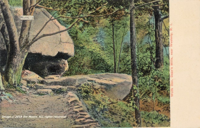
The Wolfs Den, as portrayed on an early 1900s postcard

Day Two started off by connecting with RI authority, Mike G., from whence we proceeded down into the southwest corner of Connecticut to take on Wolfs Den. Then it was all the way back up to northeastern Rhode Island to see Bigfoot Cave, the site of the mineral Cumberlandite (state rock of Rhode Island), and the possible site of an Indian encampment: Mollie's Bedroom.


At the main entrance to Bigfoot Cave


Leif's - or Norseman's - Rock

By the third day I was back traveling solo making an early morning excursion to Rocky Point Park. This was a relatively quick trip, seeing the shoreline, catching the image represented on an old postcard, and a stroll past the cave formations located nearby. Hopping across the upper end of Providence Harbor/Seekonk River, I was able to make a mid-morning low tide at Leif's/Norseman's Rock before returning northward to Massasoit's Spring.


King Philip's Cave (above) from an early 1900s postcard


King Philip's Cave - modern day

Back into Massachusetts, I took a quick look at conglomerate outcrops in the area of Luther Corner before going on down to Fall River at Creeping Rock. North again to King Philip's Cave and a look at future water access to someday visit Gary Rocks. Moving on to the Foxboro State Forest, I attempted to look up a letterbox, mostly because its description included the 'stone face'. This proved unsuccessful, so off I went to the Wrentham State Forest to Boulder Cave before retiring for the night.


Boulder Cave


The likely Cart and Oxen Rock

The fourth day was somewhat abbreviated doing more rocky formations in Wrentham, which included a likely success at finally locating Cart and Oxen Rock, a couple caves, and a giant rock pinnacle. From there, another quick run was made into Purgatory Chasm in a final attempt to locate the Fish Diet Cave. Once again - no luck. But maybe next time!


The Pinnacle

Onward home!

Sunday, April 1, 2018

Across the Wide Connecticut!


From time-to-time over the years, I've mentioned a large-scale project taking place in the mountains across (east) of the Connecticut River. I've also touched upon the fact, it is largely on hiatus due to a lack of information. But every so often, a little bit of something new dribbles in and breaths new life into it! So on Easter Sunday, I began the 'rebirth' of a new season by making that trip.

The general area under examination, are rock-cut terraces and cirques whose erosion have provided some of the most spectacular rock formations across Massachusetts. They were often visited, and fell under the keen eye of a local clergyman and photographer, during the 1860's. On this day, the section once known as 'Home of the Rocks' was the objective. A couple previously unknown antique images were uncovered, and I hoped to continue on with the identification and photographing those sites, along with others already found.


The likely Cozy Cave

The first stop was 'Kitchen and Pantry', (the likely) 'Cozy Cave', followed by the 'Curve Rock', under the 'Rock Shadow' and out into the 'Grand Porch'. The area below the Porch is 'Titan's Pasture', with the immediate area containing several caves formed by frost wedging/gravity assist. Weathering has also left massive rocks that long ago peeled away from the ledges and a few caves might also be found here. Just beyond the Pasture we run into the 'Bear's Den' and 'Kendall's Recess'.


Kendall's Recess: circa 1870. Bear's Den: lower left

After finishing photographic work in this area, it was needed to re-locate (whatever happened to my GPS coordinates?) the Devil's Pulpit and Cave. This colossal block of rock has moved away from the parent ledge but still remains physically connected. However, a cave was formed by the vacated space.


Looking through the Devil's Pulpit Cave

This much climbing on rocks and ledges is probably best suited for a bit younger individual. So after a long half-day, it was time to bid farewell till next time.

Sunday, March 18, 2018

South of the Border


The term "Scenic Route" can mean more than a well-intentioned definition for a much longer journey. The Route 8 corridor from Massachusetts into Connecticut has provided many fine, scenic memories - and explorations - over the years. In recent years: Church Rock, Hanging Mountain, and two enormous boulders at Otis and Sandisfield. South of the Border: Schoolhouse Rock, Jumbo Rock, and an unsuccesful search for Pulpit Rock.

On one bitterly cold Sunday morn, I made my way down that highway for a "meeting of the minds" (or what I like to call a "Geeks Convention") to plow over maps, exchange ideas, and enjoy some good company. Yes - the time honored tradition of rolling out the paper maps did take place, and we were able to leave one another a little more informed regarding our mutual interests in caves, geology, and archeology.


McCaffrey Falls in the southern Berkshire region

The trip home afforded the opportunity to make a couple quick stops, one being the Colebrook River Lake to check on the water level. Apparently the old town bridge, that had been left behind after the Army Corp project, was finally removed. I got in two photo opportunites just a bit farther north at a roadside waterfall and a giant rock in Sandisfield. The waterfall is apparently the same one depicted on an old postcard as McCaffrey Falls, but nowadays is generally known as Marguerite Falls.


Giant boulder in Sandisfield awaits the Spring

Thursday, November 30, 2017

Return of the Rhode Island Mountain Man...


There was an air of excitement late November, with the return of Rhode Island's own Mountain Man, Mike G., bringing his expertise to the Western Massachusetts region. I was fortunate enough to connect with him on two days (well: one-and-a-half, with an injury cutting the second day short) to visit old and new finds in the Southern Berkshires.


Mike as seen through the yawning cave entrance @ Sky Peak

The first destination was an old favorite of mine that I had not visited in nine years: Sky Peak Cave. It remains much as I last saw it, or have seen it over the past fifty years. Nearby was a cave-like formation is may have been the hide out of a man who committed murder across the state line in NY.

Sky Peak was followed by another area not seen in way too long a time: Silver Cave. This is part of a small karst area with the bedrock Owl. This being a basal limestone within the Walloomsac Formation. Similar to the much better known Owm marble within that same Walloomsac, of which Sky Peak Cave is a part of.

The day was finished just before dusk, high above the Village Of Housatonic, poking around the area of a cave brought to my attention a few years back.


Tight cave passage within the Carbonate Sliver

Two days later, we set out for a further examination into cave found a couple years ago, within a geologic phenomena called a carbonate sliver. As the name suggests, it's a 'sliver' (in a relative sense) of carbonate rock (marbles) within a large bedrock area of non-carbonate rocks (quartzose/micaceous phyllites). Finishing our investigations here, we hiked north to located other 'slivers' and a known cave that is likely within one of those. Unfortunately, a tragic accident occurred to this author, and it was enough of a challenge to make our way from the woods. Another day, to return.


'Fins' - or impurities - projecting from the wall @ Carbonate Sliver Cave

Sunday, October 8, 2017

Old Friends: The Sequel!


Recently, in my journey through Plymouth County, I re established contact with an old friend. Marjorie is a woman with many years behind her, a love of the outdoors, geologic features, and history. We originally met at Sachem Rock years ago when she, and her late husband, were tending to the property. Her family originally came from Western Massachusetts, and some years ago, she passed on to me several photographs of their excursions around the central Berkshires.


Balance Rock - somewhere around 1900

On this particular day, we talked, walked conservation land, and looked over a number of family photographs. Before leaving, she once again honored me with a small family album with photographs. Among those, was a family visit to Lanesborough's Balance Rock in 1927. Another photo, was a bit older, showing a child on Balance Rock with two possible options. Someone born in 1891 or 1901.


Balance Rock - 1927

So if rocks could talk - what wonderful stories they could tell!

Sunday, October 1, 2017

A Return...


Cave @ Crow Hills

It has been traditional in recent years, to find my way into northeastern Massachusetts during the Autumn months. In particular, Essex County. Recent times find myself making a cross State journey with stops along that way. Often in Middlesex, and sometimes in Worcester counties. This particular trip started off with such a stop - at Crow Hills. An old AMC hiking guide I've owned since the late 1960s mentions a cave here. And such a cave was located some years back. But I wished to double check that information on the possibility something else was missed. Despite a search off the southern end of the Hills, no other cave formation (other than overhang) was found.

The next stop did take me into the western regions of Middlesex County to look at a formation known as Cave Rock. Not to be confused with other 'cave rocks' looked at during the last month down Norfolk County way. This piece of geology was much more rock than cave. An erratic that had some fracturing involved and a dislocated piece that left a small opening ('cave') under one edge.


Cudjoe 'Cave'

The third stop of the first day took me much closer to Boston at the Middlesex Fells. A return visit to Panther Cave and old Cudjo(e)'s Cave were the goals. By middle-late afternoon, I was fighting my way through traffic to get out of the area and land at my campsite on Cape Ann.


Abandoned quarry and perched boulder

Day two started as an interesting day, as a sort of 'spur-of-the-moment' decision, took me down to a very urban Peabody. Which has a rich history in its rocks, including several boulder strewn moraines. I tried accessing a site located on aerial imagery, only to find condos thrown up - and in my way. A slight relocation, and I did a walking tour of a (mostly) highly developed area, once again searching for the long lost Wigwam Rock. An old bit of writing from the 1800s put it northeast of a certain body of water, but then the 1800s did not have block-upon-block of commercial buildings and pavement. Still: a later study of aerial images reveals future possibilities. A stop in South Peabody to check in on the Butts (boulder) before moving on to expand my search on one of the glacial moraines.

The third day was totally southeast Rockport. Mostly to check out a number of ocean access points. ALL for residents only. Most with little to nothing for parking. I did venture into the town center in an attempt to once again locate the site of "Oldest Inhabitant". A rocky profile formation depicted on an old postcard. Nothing definite here.


Castle Rock

A rainy fourth day kept the goals short while dodging rain drops. I headed off to Marblehead and Castle Rock. I peeked through fences of the opulent homes to try and catch a look at the Churn. Moved down to Little Nahant for a walking tour of it's perimeter (by town streets) finally ending up at a couple beaches that might make a good launch site for future kayaking. Ended the day up at Agassiz Rock reservation where I am still wowed by the enormity of Big Agassiz Rock. Close to 30' tall!


'Indian head' formation @ The Fells

Rain moved out on the fifth day, and me along with it. I cruised back on down to the Middlesex Fells to relocate small cave formations mentioned in my old AMC guide, and an 'Indian Head' formation also discovered on my previous excursion into that immediate area. Moving back out into Worcester County, I made quick work of a perched boulder reported. My final homeward bound destination, was to see another King Philip's rock that had escaped me all these years.