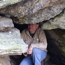
Sometime in the past, Rhody Mountain Man (occasionally known as Mike) had visited the historic Tory Cave alongside Roaring Brook in Lenox. But doubting his observations, he requested coordinates for the sake of comparison. Coordinates, I unfortunately did not have. Being a beautiful spring morning, I decided to pay Tory Cave a visit. Looks to be late in 1998 since my last visit. Coordinates and photographs obtained, I hiked on out of the October Mountain State Forest to enjoy the rest of my Sunday morning.
Sunday, April 11, 2021
'Coordinating' with a Tory
Wednesday, April 7, 2021
Old Friends and Railroad Lines
Reuniting with a long-ago hiking partner (second half of the 1990s), we had a chance to share one more adventure. Beginning in the southeastern regions of Berkshire County, and just barely in Hampden County, we attempted to trace an old railroad line. That line brought granite from the Becket quarry down into adjacent Chester where it was finished.
Accessing the site of the old right-of-way began near the abutment of a former trestle. Getting in proved to be a bit tricky but soon we were on our way along old paths and Walker Brook. As we got deeper into the woods - and higher in elevation - we began to close in on Quarry Road. Here, the ROW eventually disappeared but sections of old Mitchell Rd. could be found including former bridges that once traversed ravines sporting attractive falls.
Eventually, it became necessary to bushwack on up alongside the stream, finally making our way out to Quarry Rd. On the opposite side, a woods road was located. It provided a southerly route, parallel to Quarry Rd, with old relics such as culverts (one being a small keystone bridge) and an old, primitive shed with ancient apparatus within. We finally reached the quarry parking lot where we had left one car. So it was only to drive back to car #2, where a brief examination of the trestle abutment ensued, then on to our respective homes.
Thursday, March 25, 2021
Awakenings!
I typically start off a new season with the title "Awakenings" and this year even more so than usual. I've now reached the senior years of my life with all of its challenges. A far cry from over 25 years ago when this latest leg of my outdoor adventures began to take place. This year also comes on top of a very slow year cut to pieces by pandemic precautions. However, hope springs eternal and the planning is well underway! I expect one or two new specialty kayaks to arrive and be tested before bringing them online for a fully-fledged adventure.
So now we begin! Out in Hampshire County is a 'local secret' I've been lucky to find - and visit - a couple of times over the years. Although this is really the 'cave with no-name' I've come to call it the Hermit Cave - or even the Abode of the Hermit - after a modern-day hermit took residence, perhaps thirty years ago. This is a remote - but very beautiful - location hidden away in the breakdown of some ledges. Tarps along with pots and pans still can be found. So I can't help but wonder if it still receives occasional use to this day.
Moving on, I wanted to take a stab at relocating another old site I hadn't visited in many years. My memory was indeed somewhat 'fuzzy' regarding this one but I felt a mild sense of confidence I could dig it up once again. Wrong! The old pegmatite mining site was not to be found on this day. But upon returning home I consulted the works of the late Alan Plante and quickly saw the error of my ways. However, the day was beautiful and the exercise well worth it. Just one aging old senior trying to stay in touch with his abilities. ;)
Friday, November 27, 2020
Shades of Oliver Wendell Holmes!
This likely will finish out an (all too) abbreviated season. It is with cautious optimism, I'll look forward to another Spring. No doubt about it - it will be a difficult time during the coming months for our Country
The Rhody Mountain Man (occasionally known as Mike) descended upon the Berkshires as we joined forces in Western Pittsfield. Once upon a time, a small cave existed here but recent years have seen a new housing development likey bury it. The area we explored is underlain (to some degree) by marble providing us with a rudimentary karst area. Nothing we would expect to produce any great rewards. Like another cave or other major karst features.
After looking over a couple of resurgences, we trekked out into more remote locations where Mike's research, using LIDAR, foretold of possible sinkholes. And sinkholes, indeed, we did find! Interesting, but again, nothing major. Small signs of possible drainage and almost no bedrock outcrops. Perhaps most interesting was a drainage gully that produced a mini cave-like formation. Marble was present at this site but intermingled with other surrounding rocks.
Trucking out from the woods, we decided to relocate to the southern parts of Pittsfield to visit a cave that found its history among the famous books by Clay Perry. Elsie Venner's Cave is named after the story by Oliver Wendell Holmes and rests high in mountainous ledges that require a bit of a difficult climb. I visit this cave every few years but it was an opportunity for RMM's first visit. The cave is a chamber under rocks fallen from a higher elevation. There is even a side exit passage under an enormous boulder that has fractured. Photos taken, we returned to our cars to part ways on this particular trip. Likely, it will be springtime before I meet up with Mike once again!
Friday, November 6, 2020
In Search of Ester's!
To say the year 2020 was a 'disappointment' might very well be the understatement of a lifetime. Unless you've been living in a cave, likely your life was touch in some way, shape, or form by all that has been going on.
It was no different for me as a lot of the activities I typically pursue were hampered, or even completely closed off. Piling on top of that, medical problems once again reared its ugly head. Slowly coming back from that, I was able to connect with two good friends in a search for Ester's Cave.
Little had been heard from Ester in recent decades so we wondered what might be found - if indeed we could find it. Using some long ago directions, we climbed a significant, steep hillside. Eventually, some ledges with broken rock were located. The first thing we noticed is this was not limestone as the old directions mentioned. But a tiny entrance did exist and was explored by the two friends.
At this point, I went off through the woods to see what other prospects might exist. Covering a large section of the countryside, the possibilities for a cave were even less than the area I left behind. As I circled back, communication let me know the friends were moving on and would meet up with me along the way. Joining the two - and an area landowner - we made our way back to our cars in a more roundabout route. By this time, my injury from a couple of months back was beginning to severely hamper me. I managed to dump myself into my car and tell my GPS "HOME", ending this adventure.
Tuesday, July 14, 2020
Beyond Quabbin
A brief respite from the intense heat allowed me a small window of opportunity to make my way out beyond the Quabbin Reservoir and into sections of northwest Worcester County. Here, in two different towns, I located three new (to me) features and a revisit to a LONG ago site of historic importance.
First stop brought me to Princess Rock, site of a rather interesting story. An Indian maiden jumped off the top of the rock with her Indian brave boyfriend. Death was the escape from being forced to marry a very important chief from the Narragansett tribe. My observation was one could hurt themselves - perhaps badly - but the jump itself is maybe around 15 feet. There is a sloping hillside below, with a number of rocks that had once been part of the ledge.
@ Mine cliff circa 1870
Moving on a bit, was a mining site that has a rich and somewhat enigmatic connection in town. I have seen this described as both a gold dig and copper/copperas dig. Apparently, its earliest origins may date to the late 1700s, as when the area was 'discovered' in the first half of the 1800s, the mine had already been there! I managed to locate it with a little searching, although it had been years since my last time through the area and the forest had really grown up! One goal was to finally obtain an accurate GPS fix and I noticed an old trench along the base of the cliffs. I can only guess it was used for drainage.
Skipping several towns to the south, I located (with a little searching) the sit of an old rattlesnake den. I had been through town about a year earlier, visiting the local town hall, showing a postcard I had of the den. It was pretty well known but at that time I moved on. No rattlesnakes were present on this particular day but a pleasant surprise in finding it to be a neat little cave.
Although my last year's visit to the town hall did not turn up any information on Missionary Rock, l did have a very rough location as to where it lay. While driving along the road, I spotted three people out walking so I addressed my query to them. They did not know, but just as I was getting reading to pull away, one of their neighbors came up behind me in his car. As luck would have it - the rock lay just off the border of his property! I got a full-fledged tour with my guide, pulled out all the appropriate equipment, and eventually left the area as a happy camper filled with new information!
Setting the trusty(?) car GPS for home, I was directed south to the Mass Pike and back west to the Berkshires!
Tuesday, June 16, 2020
Remoteness of Franklin County
20+ years is a bit of time in one's life. So with that in mind, I took my act up into Franklin County for my second only visit to Camp Rock. Back in those days, I took my less than two-year-old Ford Ranger along some pretty despicable back roads to reach this geologic treasure. Coming in from an entirely different direction I was fortunate enough to have a solid woods road with open gates. My luck continued by parking within several hundred feet (later on a Subaru drove right past me up to the Rock) and soon had me at the base of this impressive monolith. At around 60 feet long, and reaching perhaps 15 feet high, its vertical eastern side provided shelter to an early family of settlers thus earning its name.
After updating some very old photographs (from back in the days when we sent out our film for developing) I moseyed on up north to the Mohawk Trail. Over the winter, I picked up a very interesting piece of old photography showing a couple of men fishing in the river near a giant boulder. It seems I may have seen it at one time in the past along the Mohawk Trail, but my aging memory is pretty dim on this one. I soon realized that safety issues of diverting my attention from the road (not to mention a large amount of foliage) would probably make this a lost cause. So when I got the chance to take the next major highway south, I turned in that direction, then took the backroads to the site of Mary Lyon's birth. Mt Holyoke College retains ownership of this property which is well kept, including a picnic table.
Finishing up photographs, it was time to head on out of a very rural location and eventually meet up with Route 9 to take me back into the Berkshires.