Monday, August 26, 2019

Ware was I?


The primary purpose on this adventure was to enjoy a beautiful summer day! After that, I wished to continue exploring how far I could take my 'compromise shoulder' on a kayaking trip. But - there is always the backdrop of working some project - or another. So two locations. In Belchertown and Ware Massachusetts.

This particular Belchertown location, I've now combed unsuccessfully three times for a minor cave formation. Not a big priority, but someday I wish to solve this mystery. The Ware River was a new experience for me. I've at least partially solved the problem of getting a mid sized kayak upon the car roof. The river is nice, albeit a bit weedy and shallow, in certain portions. An old history mentions something called the 'Skulls' in the area. No further description is available. I saw nothing unusual on my trip (such as a rock formation) even with going ashore for a brief firsthand exploration. Perhaps the most 'unusual' things seen was an abundance of turtles and the remains of an old rail line crossing.

Wednesday, July 10, 2019

North to the Adirondacks!


A BIG nostalgia trip to a (commercial) site of geologic formations! I was a child traveling with Dadwhen I last visted here many years ago. Part of a regional cave convention that took place that weekend which included visiting the large Crane Mountain Cave.


Approaching the Bridge

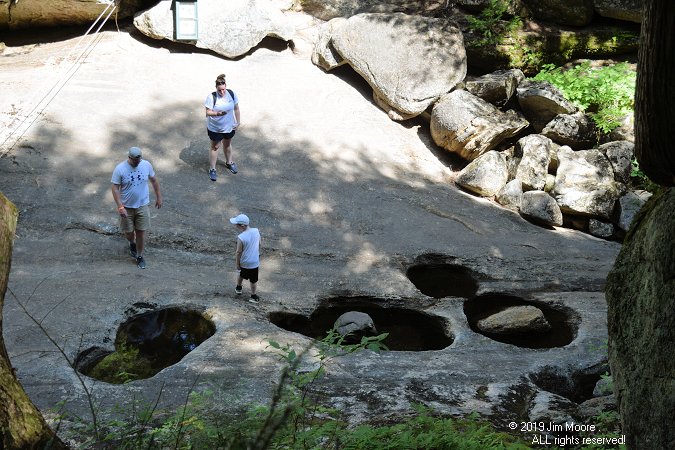
Years later I had the opportunity to experience this section of the Adirondacks with good bud Gary from Great Barrington. Natural Stone Bridge was all that I remembered - and some. Very nicely done for a 'commercial' attraction. Plenty of caves to be seen. Lots of history and explanation of the geology clearly outlined.


Some of the pothole formations

On the return trip, near the State line, we passed by two cave locations in search for their entrances. One was long ago taken out by highway construction. The other, we did not have clear enough directions to.

Saturday, June 1, 2019

Along Comes Worcester County!


The desired goal was a combination of two areas: the Essex-Middlesex Counties, then finish up with Mike G. (aka: Rhody Mountain Man) down in southern Worcester County. The weather has not been cooperative enough to string that many fair days together and it did not happen. So, it came to pass to build what I could around the day I was to meet Mike down in Worcester County. That resulted two days covering central Massachusetts leads.

It all began when I landed in an eastern Quabbin town to see what could be dug up on a Rattlesnake Den and a Missionary Rock. Information gleaned at the local town hall netted me a fairly accurate location for the Den - but near the local school, so that was set aside for a future date. Missionary Rock (like so many) is still a 'work in progress' as I try to narrow down its location.


Shelving Rock

From there, I backtracked slightly to the northwest to catch Shelving Rock, the site of an early settler's shelter before he finally built a more permanent residence. Then over to the local Audubon property where a waterfall, a chasm, and a small cave was to be found!

Next up was Mount Wachusetts for possible identification of two old postcards. Unfortunately, nothing definite despite one intriguing reference to a cave along the Mount Wachusetts road.


The Double Boulder as the Poised Rock. Circa 1870s

After jumping over to the east of Worcester for the night, come morning, I headed southward to the famed Purgatory Chasm in Sutton to meet Mike. I had combed the area at various times hoping to locate Damnation Cave. Withe Mike's help, a definite fix on its location was to be had. Last year I was apparently in the mouth of the cavern but failed to make a positive ID upon it!


RMM extracts himself from the depths of Damnation Cave

After a quick tour of the rest of Purgatory, we moved on to the next Town west for further investigations in Clara Barton's (Red Cross founder)ramblings through the local woods. Both of us had looked through the woods for several reported sites of caves used by Clara/ and or other local figures. Several rocky - but VERY small - formations had previously been located by Mike. We visited those before saying our goodbyes and returning to out respective homes.

Saturday, May 4, 2019

Berkshires and Rhode Island connect in Connecticut.


On this particular day, the Rhody Mountain Man (occasionally known as Mike) connected with myself, and Connecticut's long time caver Peter F., to continue the 'process' of locating Dutchy's Cave. This being Mike's 7th(?), and my second trip in pursuit of that goal. It's not that Dutchy's is a 'lost cave'. It is know to locals, but outside of the area - few do know exactly where it may be found!

The hike is is a bit of a jaunt being around 2.25 miles, following the Naugatuck River for a little over half of that. Then it was a turn up into the hills, fortunately a trail made that a relatively easy route to follow. Upon arrival at the 'new'suspected located, we spread out to initiate a search. A tiny bit off on the location, however shortly after our arrival the site, the cave was found!


A check of the equipment outside of Dutchy's Cave

Dutchy was a gold prospector from the Civil War era, although this site was unlikely ever a gold producer. Fool's gold might be a possibility as the right mix of minerals are present. There is a good indication of mining near the mouth of the cave including drill holes. The cave also offers an assortment of carved initials, including one dated 1779.


Examination of the interior of Dutchy's Cave

Saturday, April 6, 2019

And now: Spring!


With the arrival of a new Spring season, comes the chance to test the aging body. To see what another year of diminishing physical attributes might offer. Of course I speak with a bit of wry humor as after all - it is what it is.


Falls @ Robbers Cave - early 1900s postcard image


Against that backdrop, I began another year with good friend and partner Mother Nature. The first outing took me down south of the border into Connecticut where it was a day destined to be part social - part outdoor activity. On my list has been a sight know in past years as Robbers Cave that indeed did have an association with a long ago crime in Winsted. This is a rugged area that can be approached from several directions but in the end it is either from the bottom - or the top.

Joining with a friend, we took a stab at coming in from the lower elevations which necessitated a lot of climbing, often over very large boulders. Eventually we turned back near a small waterfall believing we were in close proximity, but still not quite at the site. This was later confirmed to be true when the two of us joined area cavers at an anniversary get together later that afternoon. So a future trip is planned.


The Devil's Tombstone

The following weekend brought me together with a south county bud for a trip on over to the Catskill Mountains in New York. The first stop was the famed Kaaterskill Falls. We poked around a bit looking for access to rocks known to be in the area (such as Alligator Rock) but many roads were found to be closed this early in the season. Then it was over to Stony Clove for the Devil's Tombstone (also known as Picnic Rock and even Pulpit Rock) before heading up to Prattsville for Pratt Rocks. On the ride back towards Catskill, we got a quick glimpse of Road Cut Cave (if it is even still open) a childhood memory when I visited it before this section of highway was opened.


Two of the formations at Pratt Rocks, Prattsville NY

Back in the Berkshires, we caught up with a neat perched rock not far off a back road, but still 'new' to the two of us! BR>


Perched rock - southern Berkshires

Friday, January 4, 2019

Something Old ... Something New!


Taking advantage of both some unusual winter weather (particularly lack of snow cover), AND some solid leads, it was off to the Connecticut River Valley!

First stop was in an area of Northampton, which has its own bit of history: Laurel Park. http://www.laurelparkarts.org/historical-laurel-park/ I've visited here on one previous occasion to search out another old postcard of Boulder Knoll. Today's trip brought me in search of Sunset Rock. Surprisingly, only a small amount of effort was needed to locate the boulder(s) which were found in the undeveloped woods. In reality, this is a split rock formation with a very clean, smooth cleavage. Not terribly big, but the postcard is the work of postcard maker Eddy Make, who operated out of Ware MA during the early 1900s.


Rock Roof - circa 1870


The Rock Roof - present day.

A short drive to the north, landed me just over the Connecticut River and in the midst of a long time, but mostly dormant, project. Dormant yes - but not dead! An influx of antique stereoviews, from Amherst's renown photographer John Lovell, has found its way to me! So once again picking up where past investigations left off, identification was commenced on the unorthodox geologic formations. Among the long forgotten sites confirmed were Russell Rock, Titan's Quarry, Tripe Lichen Ledge, and Myra's Retreat. Updated information was obtained on Castle End, Rock Roof, and Kittie's Nook.


Present day at Myra's Retreat

In the end, today was only a small part to setting the stage for a much larger expansion on this project come spring time. In all, 10 'new' images would come to me. Some sites (like Kittie's Nook) were previously identified from written records. It only remained to see exactly what the photographic eye of John Lovell captured on his trips through the wilds.

Tuesday, January 1, 2019

Finding Balance on the First Day


The image of a little know Balanced Rock near the Flag Rock section of Monument Mountain, provided the driving force for one First Day hike. The man behind this was Great Barrington Historical Society's, Gary L. The source was an early 1900s glass slide, photographed by a local man from Housatonic.


The Balanced Rock, near Flag Rock. Early 1900s.

Ascending from the 'back' (western) route, we made out way up approximately 675 feet of elevation to Flag Rock. Along the way, passing by some enormous boulders with their own cave-like formations. The view from Flag Rock, to the west, is nothing short of spectacular! Our directions had us bushwhacking to the south. Here, where the mountain began a steep drop off, we found our rock! One item of interest: the rock seems perched upon several small ones beneath. In effect, making this a pedestal boulder.


The Balanced Rock - Present Day.