Friday, April 22, 2022

Hunger and the Elephant


A new year. A new season. And further experiments into the experience of aging! ;) So I rolled on down through the Tyringham Valley, passing Gorilla Rock and Rabbit Rock.

Today's adventure brought me to the southern Berkshires, joining the Western Mass Hilltown Hikers in Monterey. The hike took us into a section of the Beartown State Forest, visiting the Mount Hunger Cemetery, and eventually climbing the steep Mt. Hunger itself.

Elephant Rock - early 1900s postcard

The 'geologic portion' of the trip was a short drive to local landmark Elephant Rock. Its been years since I last visited this magnificent boulder and I wished to determine if it be marble or not. The old favorite acid test did react positively but indications (at least at this early point in time) are it may be what it was thought originally: sandstone. BUT, a sandstone with a small calcium carbonate mix.

The final stop was to the shores of Lake Garfield to ponder furture hiking and kayaking in the area.

Friday, November 19, 2021

Tekoa!


Helping Mike finish this year's trip to Western Massachusetts, we met at an access point north of majestic Mt. Tekoa. The goal was to check the summit ridge for a reported cave, then continue the hike a ways towards English Grass Cave.

View from the summit ridge of Mt. Tekoa

Some prep work, along with modern GPS and mapping technology, made accessing the Tekoa Summit fairly easy. But along the way we quickly became aware of severe trail flooding with impoundments creating small ponds at certain points. After reaching the ridge that looks down on the Westfield River 900 feet below, we followed that ridge to the northwest to use the existing network of trails (along with a moderately long bushwhack) to eventually end up at English Grass Cave. A lot of walking and a lot of climbing involved. Upon our departure from the cave, it was one more lengthy walk and a bushwhack to skirt a pond covering the old woods road. Beat up and tired, we eventually reached our cars and said goodbye until our next adventure.

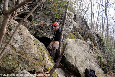
Mike extracting himself from English Grass Cave

Monday, November 15, 2021

Mike Does the Berkshires!


November came calling - and that is the time of the year that heralds the return of Mike, the Rhody Mountain Man. He had a well prepared list and we set of (after breakfast) to seek out something new for both of us: Kelly's Caves. The area was part of a favorite of mine, a small mountain in the foothills of Greylock known as Sugarloaf. The whole area is a 'sort of' karst area boasting 'caves' of different origins. There is some bona fide karst in the marble surrounding parts of its lower elevations and the section area we explored was an area I had never ventured onto.

Mike descends into one of Kelly's Caves

But Mike had some pretty good coordinates for the area we sought out and with a bit of bushwhacking, we eventually landed in an area of a sinking stream. Two small caves were to be found. But, in the end, fill made them somewhat short, . While Mike checked out the underground I roamed the forest seeking out evidence of further karst formations. This proved to be fruitless and soon we were headed on our way out of the woods.

Mike searches through the talus for Bear Cave

On our next stop, we sought out a somewhat vague mention of a cave up a steep hike in Williamstown. It basically was a geocache site in the Pine Cobble region, located among a tremendous slide of talus. The definitive site of that cave could not be totally confirmed after much searching. We moved along, then on to our prospective homes.

Friday, October 29, 2021

Chester quartz

One more hike with the Western Mass Hilltown Hikers and 'old' bud Tom (really - I'm older than Tom). This took us into Chester once again, one of the most heavily mined towns I've come across in Massachusetts. One of the group's members is owner of the land and was our host for the morning.

A boulder of interest.

The property is quite hilly (indeed, the access road was something to marvel at!) and we began an extended hike though woods with occasional views of Chester far below. A quartz quarry was the ultimate object of our walk and was the last thing we encountered. A deep open cut into the rocks, with partial collapse, was all that was left to see. Along with a few drill marks.

Exploring the interior of the quartz (rock cut) quarry.

We pondered what quartz might have been used for. It was during my later 'debriefing' it apparently went into the manufacturing of porcelain. Chester even had (at one time) a manufacturing operation that made use of the local quarried quartz. And Chester, long known for it's emery, did indeed have numerous quartz quarries.

Sunday, October 17, 2021

Byrant!


Sometimes it's nice to 'kick back' a bit and do something that leans more towards the recreational rather than the many, much more, intense excursions I find myself on. On this nice Fall day, I rode into Cummington. A town I've traveled through oh so many more times than I could remember. It is often on my main route to and from the Berkshires. The destination? A place (believe it or not) I had never visited: the William Cullen Bryant Homestead. A Trustees of Reservations property.

Under the forest canopy!

Today's walk was lead by naturalist Aimee Gelinas of Tamarack Hollow in Windsor. It was the quintessential hike through sylvanian wilderness that encompassed learning opportunities on a variety of subjects. Subjects such as tress, fungi, and even a smattering of geology. For those wishing to follow our route, it took us down the Rivulet Trail. Near it's farthest point, we diverged onto the Pine Loop which did bring us back to the Rivulet and our way from the forest. Picturesque all the way!

A fine specimen!

Thursday, October 7, 2021

Just over the Line.

A wet insurgence entrance to Merlin's Cave

This trip was focused on just over the border into New York State. Here liesproperty of the Notheastern Cave Conservancy. Two nice caves, Dragon Bones and Merlin's, may be found. But both are closed to human exploration during the winter mortoriuum to protect the bat population. However, Merlin's is considered a very challenging cave and beyond the capibilities of the two old seniors hiking about the preserve.

The twin tunnels. Left one abandoned

Adjacent to this cave preserve is a set of twin railroad tunnels. The more northern of the two, is the oldest being constructed about 1840. It is now abandoned but the southern one (built in 1912) still sees use.

Thursday, September 23, 2021

The Other Cape!

One of the balanced rocks @ Franklin Park - early 1900s postcard

More and more in recent years, I've been known to say aging may be the last, great experiment in one's lifetime. As a bona fide senior I find it sometimes goes well. Other times not! And so it was on a traditional late summer/ fall trip up into Essex County. For the most part it was devoted to Cape Ann, celebrating 20 year ago I first landed at the local campground. But in the end, for whatever reason, the overall trip had to be devoted to a lighter set of activities.

Part of the Ruins. Boulder with Emerson plaque.

My goal on the first day was to put time in at Franklin Park defining the locations of it's many boulders, particularly in the Wilderness section. But first was a social call on the edge of Newton to have coffee with a friend from recent years. By the time I reached Franklin Park, it was a busy Saturday with activities going on. I got in a nice trip to locate someof the boulders, check out possible locations for Sunset Rock, then it was over to the ruins at the Overlook. That about shot the major portion of the day leaving much more to be done in the future. From here it was onward to Cape Ann!

Small sea cave formation around 1888

The winds were blowing a gale on the second day, so further testing on the new kayak was put on hold. I did make the 'tour' around the coastal areas, looking into Lanes Cove, Folly Cove before landing at Halibut Point. A lot of good hiking at Halibut but the pathways going down towards the ocean get to be a bit more strenuous. After finish up at Halibut it was off to one of my favorite all time places: the Atlantic Path of Pigeon Cove. An assortment of rocky formations lie here and I did visit several including Singers Rock and Chapin's Gully. Then a walk along the road just off the rocks (and a quick 'dive' into Andrews Woods) brought me by some rock sculptures upon a private lot. Next in line was the Town of Rockport bustling with tourist activity. I used this visit to locate any possible downtown access points to the ocean. I finished Rockport at the Headlands then it was off to the Magnolia section of Gloucester. Here I explored the Shore Rd area which included the Great Stone Face/Lady of Rock. The day ended at Good Harbor Beach where low tide enabled me to see the passage over to Salt Island and the tiny sea cave opposite that island.

How the old Coggeshall Camp looks today - from the ocean!

Some of the cliffs that line Folly Cove - early 1900s postcard

The morning of my third day was intriguing to say the least. I had a lead of an Indian Rock within the Gloucester boundaries. At one time long ago, it was a big time party spot for the local youngsters. Almost a local legend, it seems no one had been out to visit it in recent years. But with a few directions I made my way into a 'secluded' spot tucked in between sections of neighborhoods. Some development had encroached upon the purported location so it had to be determined if it still might exist! Well, it does not take long for Mother Nature to reclaim land that gets little use. I almost literally had to claw my way through dense overgrowth that was a lot of briers and sumac. By the time I exited this mess, I left disappointed and unsuccessful! But of a more relaxing nature was a cruise out of Lanes Cove, putting the new kayak through it's paces on the open ocean. Sites passed as I head north were the location of old Coggeshall Camp and Folly Cove.

Rocks towards the end of Cressy Beach - including the sea serpent!

Day four brought me off Cape Ann as I planned to do some exploring around Marblehead. I started off in one of their very old cemeteries. Then I left the mainland behind to head over to the Neck. Big time favorite Castle Rock was my destination but I just missed low tide and access to the small sea cave in the area. But I set up and grabbed a number of good photos of the old Rock itself before exiting Town. Back in Gloucester, I used the opportunity to visit Stage Fort Park and it's beaches: Cressy and Half Moon. Before landing back at my campsite I went up the road to Wingaersheek Beach where low tide was prevailing.

Entrance to small cave in Dogtown

On Day #5 I wanted to make one more trip up to a favorite location on the shores of Pigeon Cove. On the way, I visited the Granite Pier, and the Pigeon Cove Breakwater. Then it was back out onto the rocks that I've spent 20 years enjoying. With that behind me I had to make at least one small trip into Dogtown. The choice was the two caves first visited some years back.

Indian Rock - found!

Pulling camp on the morning of the sixth day, it was a decision on "what to do?" before leaving Town. I had been in touch with one of the local people over Indian Rock, with a little more information provided. But did I want to brave the 'forest' that tore me up badly a few days earlier? Ultimately, I said yes and on my way I went. Taking it slowly - and altering my course slightly - once again I was enveloped in sumac and briers. I eventually spied some painted surface and made my way over to it where I was rewarded! Indian Rock at last! It was so completely surrounded by growth you could not get back enough for photo. But signs of the past were present including old beers cans and broken glass - and lots of old paint upon the rock. Extracting myself from a messy situation, I accessed the car, caught Rt 128 out of Town and made my way to the Mohawk Trail and back to the Berkshires.