Monday, August 31, 2009

It is with a certain amount of regret I must realize that many of my projects continue to fall by the way. Living way out in the western part of the Bay State does not make 'do-able' (most of the time) travel to eastern parts and down into Rhode Island. But with that said, I am in a good position to continue on working the Connecticut River Valley. So on a day that seems to herald the oncoming of Fall - I returned.

So on I continued with my deliberate and systematic search of ledges within the Valley mountains. Picking out a section that on the topographical map looked promising, I parked and headed out into the woods. Once again I hoped that I might come across the long lost "Warner's Ledge" photographed some one-hundred and forty years earlier.

With time, things (of course) have changed and access to the mountains is often blocked by nice spiffy newer homes. But finding a rare piece of property not built upon, I made my way into a series of conglomerate ledges that yielded but a couple of very small cave formations. I zigzagged on up in elevation until I stumbled on in to an old 'friend' in the form of Graves' Ledge or the Rock Shelter.

I always can find something new - or check some of the old photography done here - so I decided to proceed down the entire length passing all the favorites at Castle End, Etta's Nook, Rock Roof, etc., etc. and finally pulled up at Willard's Point. Consulting with my stash of antique photography, I realized I had not done a good job previously in matching my modern day photographs to the older one. Careful analysis, and correct positioning of the camera tripod, brought me a much better representation although the Point itself is now somewhat obscured by the trees.

Adjacent to Willard's are the Twin Slabs which really are a section of the conglomerate ledges that have tumbled forth and landed upon their sides. And just beyond this, the always impressive Rock Rift. I mulled over the possibility of a photo shoot but with heavy tree cover found it not worth the effort at this point in time.

It was at this point I decided to do Graves' the whole length. Something I had not done since I originally stumbled on into it some five years ago. So the next Victorian Age feature in the photographic series was Fortress Rock. This section of ledge is a mighty monolith of stone separating into two levels just beyond the Rock Rift and running for a couple hundred yards only to come together again near the site that the old photograph depicts.


Annie's Retreat in the Connecticut River Valley

Annie's Retreat

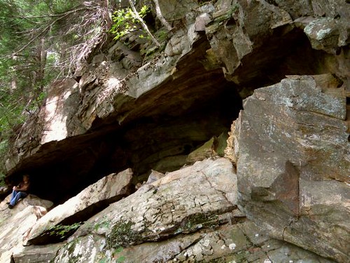
Upon leaving the 'Fortress' the massive ledges continue on a bit farther with Annie's Retreat being the last in the photographic series on these set of rocks. Annie's is a comfortable cave formation in the base of the rocks and would be the ideal picnic spot in The Victorian Age or even today. From here I followed on out what rock ledges were left. Then down from the mountain to the highway and back to the car.

Friday, August 28, 2009

Shadows of Ashintully


Tytus' Den; Berkshire County

Tytus' Den

My next visit took me to the region of southern Berkshire County. Back in the earliest years of the 1900's, Robb de Peyster Tytus assembled the Ashintully estate from several farms in the valley of Tyringham. Dying at an all too young of an age, he, his wife Grace, and one of their children, are buried on a local mountain top.

The mountain also boasts magnificent forests, a picturesque stream, and a cave of sorts weathered out from the ledges of yon mountain.

Monday, August 17, 2009

Route 7 is an old historic highway I've traveled much in past years. Not so much in recent time. It winds up past some of the best karsts in the northern half of Berkshire County. But on this particularly brutal hot summer day my destination was Massachusetts' most northwestern community: Williamstown. After hearing of Stone Hill for a number of years (and its associated geologic feature: Stone Hill Slice) I decided the time had come to investigate it. I also had two postcard images of an early 1900's couple at the "White Rock" and thought it might be worth a look for this feature also.

I made my way up the old road that is said was once the original road into southern Williamstown village. Deep into the woods I began to see the long, massive wall of quartz that made up the western face of Stone Hill's summit. Just beyond this was a stone seat constructed as a memorial to Williams College professor George Wahl. A bit farther to the north is a curious boulder lying in a small grove of trees. It appears at first glance to be a blue-gray rock - probably marble - interspersed with significant quantities of white quartz. On the return to my car, I gave the quartzite cliffs, and immediate summit area, a cursory exam saving the harder work for a much cooler day. So although the location for the "White Rock" postcards was not found, I already am working another idea of its locale.


A geologic cave entrance but not physically enterable
at Carmelite Caverns


A short drive to the nearby Carmelite Caverns (not visited in many a year) provided a previously unseen view into the cave's speleology. Here we have the rough boundary between the e and d marble units of the Stockbridge Formation. Interesting to note that this same bedrock alignment exist at a small series of caves about a mile to the south and at the Mc Master's Caves perhaps a third of a mile beyond those.

Wednesday, August 12, 2009

Anatomy of a Profile


Let us take a brief respite from the heat, humidity, and bugs to travel back into times past.

Long ago on a (still) well visited beach along Buzzards Bay lay an attraction know as the Profile Rock. It never looked liked anything to me, both from a personal appearance and all the postcard images floating around the internet and at old shows. One old postcard even had the audacity to put in writing on its reverse side; "At certain times of the tide and with the sun in certain positions there are many remarkable profiles discerned on this rock." I was still not impressed as the 'best' I saw was a 'beaky', buzzard-like appearance.


Profile Rock @ Buzzards Bay: 1890's


But long ago during the 1890's some enlightened soul decided to produce an image of said profile. Now we're getting somewhere! A rough outline of a human face could finally be seen. As for all the old postcards (of which many exist) if it showed that side of the rock, yeah, maybe we could see that profile.


Profile Rock

Profile Rock @ Buzzards Bay: early 1900's


But time marches on and the modern age brought in beach improvements. With sand and a shoreline farther out, the profile of Profile Rock became largely buried - and forgotten. Forgotten? Well, not completely as long as there are those that thirst for history past. As for this author - my next trip to the profile rock will include a shovel.


Profile Rock

Profile Rock @ Buzzards Bay: 2003

Sunday, August 2, 2009


Water wheel at Terryville, CT

That time again - for a visit to Connecticut. By nature this is more for rest and recreation but the shadow of history - and even geology - is not far off.

First stop was in Farmington at the Hill-Stead Museum. Here, magnificently preserved, is a home harkening back to the golden age of opulence during the late 1880's. Within its walls are an art museum from the collecting of the original owner who was one of the early enthusiasts for Impressionist paintings. Much stone was worked into the exterior of the home, including it's pasture walls and gardens, and yes - the grounds once had its very own quarry. Also on the grounds (after a quick trip to the local model airplane airfield) is a modest set of hiking trails that lead through forests, swamps, old apple orchards, and one can even join up with the Metacomet Trail running through the neighborhood.

Connecticut history also boasts a series of canals. One of these once ran through the Southington area where part of an old railroad line has been turned into one of modern age's popular bike trails. Upon reaching its end, the old route continues off through over grown fields with the remains of an old bridge across the Quinnipiac River.

The second day was devoted to visiting a pretty nice park in Bristol - Rockwell Park. Lots of old stone work, a spring, ponds (one now non existent), and a system of hiking trails. Afterwards was an environmental park with its own trails winding through bogs and woodland. Finally, with light rain falling: the old water wheel in Terryville, presently under renovation as park of a public park.