Saturday, November 13, 2010

The Nutmeg State


November is traditionally the time I journey on down into Connecticut. Rest and relaxation is the first order of business but certainly included in there is a chance to explore different territories, different histories.

Day One started off on one - of many - old railroad lines that have been converted in recent years to bike paths. This one in Farmington took me across the Farmington River, north, past an abandoned side line. This spur ran up to a somewhat dilapidated building that once held a former business, while the rail trail continued it's northward journey for many a mile more. On the return trip, after traversing the River once again, a pleasant surprise was to be had in a more rustic trail, that wound it's way along the river bank before returning near the vicinity of the parked car.

Another, nearby, bike path also along a former RR bed) was scouted by car before retuning to another section of the Farmington River that once carried the Farmington Canal over over the river by way of a viaduct. All that remains are a couple abutments and foundations.


Is this - or is this not - a profile?


Day Two was devoted to the shoreline after a quick spin past a local rock that a previously investigated trolley line once ran through. Upon arriving at Lighthouse Point in New Haven, lighthouse, rocks, and other historic features from the past were given a going over.

Then on over to the other side of the bay where a gem of local history lies in Savin Rock. The "Rock" gave it's name to a once thriving - and long gone - amusement park. Today a museum remains as well as an ocean walk. But my interests were once again drawn to the rocks where one old postcard mentions a 'profile' and Savin Rock. It is not entirely clear if this is meant to be a 'facial profile' in rock (maybe a possible interpretation) or profile in it's more general meaning - as in a side view. However, photos were taken for later study, and the perimeter of Savin Rock itself was studied where one profile of an 'old man' type could be found.

With the Savin Rock museum closed, research was limited on the return trip to the cuisine of the famous local hot dog stand. Two thumbs up on this 'historic' and tasty location.

Wednesday, October 13, 2010

Back to Cape Ann


This is the one I look forward to all year. The annual return to Essex County which has me staying out on Cape Ann. This year I had enough on the Cape to keep me busy but first...

Day One: Coming in by the standard, routine approach - Rt. 128 - I stopped in at one of my old favorites Ship Rock in southern Essex County. It is always a challenge to try to photograph this boulder because of it's enormousness size and generally I arrive during early day when the rock is drenched in sunlight. Moving on a bit to the southern perimeter of town I reexamined a patch of conservation land just littered with glacial boulders, some of significant size. One worthy specimen is a classic perched/balanced rock just over 60 feet in circumference. Last - before pulling out of town to set up camp - I ascended at ridge quite close to the town boundary where power lines had opened a path showing dozens upon dozens of perched boulders left from the glacial age. All this area was once the object of study of the Essex Institute - now merged with the Peabody Museum - during the middle 1800's.

Day Two: Some excellent Fall weather and I took to the most northern portions of Cape Ann. A local woman had provided clues to a couple possible caves in that area and searching coastal areas found a couple cave-like features formed in gigantic boulder piles. I later confirmed this as one of the caves mentioned to me by the local woman. I followed this with her second lead passing by old quarries (of which - many exist in this area) to a ravine I thought might be the cave location. With nothing seen here - I moved on.

Devil's Den & Profile Rock


The Devil's Den, along with Profile Rock

Down the coast is Pigeon Cove, the location of many old photographic and postcard images. Especially of rocky formations. One is the Devil's Den and Profile Rock. Success was to be had at locating this old site. Still further south lays a section of Gloucester once know as Joppa. A good chunk of woodlands was covered in another less than successful attempt at locating the Old Man of Joppa profile formation. After chowing down some bogus supermarket pizza, I decided to work off my meal in the southern extremes of Dogtown visiting Tent Rock and five of Babson's inscribed boulders.

Dogtown

The expanse of Dogtown with Uncle Andrews Rock (aka: Babson's 'Spiritual Power' boulder) to the far upper right. From a 1890's glass slide by W. S. Beekman.


Day Three: Now we come to the Dogtown walk. Wouldn't be a visit to Cape Ann without one significant hike through the moorlands that once was the main settlement of Gloucester long before residents took to the coastal areas. Working with a newer publication I picked up late last year, I walked a unnamed trail down towards Babson Reservoir where my book told me rocks larger than Uncle Andrews and Peter's Pulpit - two of the largest erratics in Dogtown - might exist. Although numerous boulders were to be seen - some of pretty big size - I cannot say they exceeded the aforementioned rocks in size. But I made a circuit by coming back up the Babson Boulder Trail and verifying that the backside of Uncle Andrews Rock (aka: Spiritual Power) was the site represented on an old glass slide I picked up the preceding winter. Cellar hole #23 (stone seems to be missing) finally was located. This one belonging to Col. Pearce, a wealthy Gloucester family, and one I had an postcard of the old cellar hole.

To the northeast, near the Goose Cove Reservoir, another section of old Dogtown was investigated. One cellar hole marker on the road in was found, one on a rock in the Reservoir (visible only because of low water), and two were found along the city street leading away from the waters. Goose Cove has(had?) a small waterfall depicted on an old postcard. The site was located but with water running on the low side, did not appear particularly significant.

Once again shooting out to the northern extremes of Cape Ann, I further worked cave lead #2 from two days ago, weaving my way through many an old quarry, but still finding nothing noteworthy. Then out to the ocean side at two locations, at one - visiting Chapin's Gully and the Great Gargoyle.

Day Four: Down in the urban town is a patch of nature that survived and is known as the Magic Garden. Following my visit to the Garden, I returned to scour another section in Joppa coming across interesting boulders and ledges but no Old Man. Coming down the coast I decided to spend my final hours in town at sentimental favorites in George Washington's profile and Rafes Chasm Park. On the way back out of the area, I found my way to Singing Beach at Manchester looking over rocks at both ends of the beach. Postcards depict Eagle Head (shape of an eagle's head) and one of the Sentinel (rock). After experiencing the 'singing' of sand beneath my feet towards the beach's southern end, it was time to leave Cape Ann once again...

Addendum: The return home brought the usual sifting through, and going over, all that had been gathered. Additional research brought up some very interesting information on sites in the vicinity I had just covered near Ship Rock, et al. Long sought Wigwam Rock appears to have been mostly taken for construction purposes some years back. Still I would like to pinpoint its location. Lookout Rock, also once looked for, has showed up on a map with a pretty definitive location. And a new entry: Kimball Rock. All will be worked on during future visits to Essex County.

Sunday, September 26, 2010

Chapel Brook


A casual, laid back day, as once again I joined area naturalist Aimee Gelinas and her group. Destination this time around was the Chapel Brook property of the Trustees of the Reservations. The two primary features located here are Chapel Falls (mostly dried up from summer draught) and Pony Mountain with its rock face favored by technical climbers.

On this day a magnificent view was to had from Pony Mountain's summit with trees just beginning to show their fall colors. Also seen: several very old trees and one cellar hole.

Wednesday, September 22, 2010

Return to the South Shore


In recent years this aging baby boomer takes himself during September on out to the South Shore area in the Bay State. This year was no different. Stops are often made at various locations both to and fro.

Day One: Ditching off of the Mass Pike for a short jaunt down Rt 128, my first stop was ... a flat tire! Once that issue was resolved, I made my way into northern Wellesley to the Boulder Brook Reservation. Nice area to find in a basically suburban neighborhood but not much for boulders despite it's name. Perhaps it's main feature is a side of Rocky ledge which also marks the boundary with the town of Weston to the north. Nearby is a big boulder (sometimes called the Bates Boulder) in another park - Kelly Park.

A bit to the other side of town are the remains of an old estate from the second half of the 1800's carved up long ago into more suburban neighborhoods. I first visited the area some twelve years ago and found residents - at least the one I talked to - very gracious. Apparently with new owners, the situation has changed significantly. It is now patrolled by security officers. So attempts to update information on this area was largely futile.

Moving on down to The Blue Hills I initiated two searches. Both basically turning up nothing. The first was an attempt to find the location of a Rattlesnake Den written about in an old publication from the early 1900's. I started this last year and continued by covering a slightly different tract of land. Although I saw plenty of rocks on this visit (hey - after all - this IS the Blue Hills!) nothing that would fit the description. A small cave formation called the Hermit Cave by its modern day photographer also did not turn up, but likely just the wrong area was searched.


Early morning at the Burbank Boulder


Day Two: Early morning brought me to the eastern region of the Wompatuck State Park for a reexamination of a small cave found there several years early. Perhaps Rattlesnake Den might be a good name but then it would confuse matters as history records another site nearby with the same name. But a closer examination shows much of this cave's origin is due to displacement of a large, fractured piece of the parent outcrop. A similar - but smaller situation - would be seen later in the day within the same town. I finished the walk by making a circuit past the Burbank Boulder (incidentally: slightly wrong location is marked on their trail map) and trying (in vain) to find legitimate access to Cleft Rock before breaking at the nearby Scituate Library.

Emerging from the Library I made the short distance to the local historical society to further work on another lost erratic called Damon's Rock. Although it seems after numerous tries, I finally have narrowed its location down. But another site where access may be a dicey situation. But being already down by the ocean, I made the tour up the coast visiting the Nubian Head Rock, Well Rock, and the Old Man of the Rocks before heading back into Cohasset.

At the Cohasset Historical Society, I shoved a recent eBay find under their eyes for possible identification but to no avail. Afterwards, in driving part of the coastline, I caught a distant view of Daniel Webster (profile rock) sitting at the ocean's edge. Down on the boundary between Cohasset and Scituate is a rock at Bound Brook, incorporated into and old mill site. Landing Rock, where I was told baptisms once took place, also lies in the vicinity pretty much shut off by private land.

Great Brewster Woods (access behind the Cohasset Town Hall) is a fine walk and the site of one Lion's Den whose exact location is somewhat lost to history. In the past I thought it to be a marginal cave formation in the far northern parts of the Woods (also formed by displacement of a section of ledge) but now believe it was one of several rocky ridges within the GBW.


Part of the Cavern Rock complex


Day Three: A more leisurely pace than the preceding day, I caught up with some work at the local wifi spot. Then heading into an adjacent town I looked into a reference by eminent geologist Crosby from the early 1900's. He mentions a feature resembling (but much smaller) than nearby Cavern Rock. Indeed a small spot survived amongst much developed land that contained minor rocky formations. Wether any of these were what Crosby had written about is uncertain. But speaking of Cavern Rock, since it was nearby, I dropped on by to update my photos on this spectacular rock formation.

In another part of Town I continued the ongoing search for what some have called Writing Rock. Each visit seems to bring me a bit closer and local "Dave" talked with me at great length about the neighborhood which was once part of a large estate. Somewhere in this area the rock should exist.

Skipping over a town I was granted permission to examine Rocky Woods. One of several such locations with that name around Massachusetts. Even though I only saw a portion, indeed it had much in the way of erratics and especially high, rocky ridges. I had theory that a lost "Devil's Den" might lay here but that did not prove true - at least on this visit. But to the north is the Town Forest where one individual I've contacted in the past believes Devil's Den might have - or may still lay. But some pleasant walking was to be had and I revisited the Garden of the Gods, an area of glacial erratics.


The rock ledge from which Rock, MA takes its name.

Early 1900's postcard


Day Four: Seems there is no end to the heat of summer! With a hot day building before me, I decided to put in a short day before making my way home.
I had what I thought might be an alternate access to a site I visited last year outside of Plymouth where one - of two - possible "Devil's Rocks" might lay. My access road soon turned up as invalid and after checking out an access point to the local river, I moved on.

Better luck was to be had farther east in Plymouth County where a possible Indian mortar/grindstone was examined. For real - or not. One cannot say. But the day (and trip) was brought to a conclusion in the Village of Rock where after several visits, the location of the ledge (and old postcards) from which the village took its name was verified.

Sunday, September 12, 2010

Rum & the Devil


Rum Rock

Under somewhat threatening skies, I made the trip over the northern end of the Quabbin Reservoir for an abbreviated day. I continued on with a project from the early June vacation when this area was hot, humid, and very buggy. But on this much cooler day I finished searching out yet another Devil's Den. Not much here but some extended ledges and very small cave formations. More like porkie dens would be a better description.

But Rum Rock is in the same general area, and I've been somewhat stymied in obtaining decent photos, so I dropped in on that giant erratic as well. Nearby is an "old Indian cave" or so I ws told by a local history authority in the past. Whether it's true -or not - is once again lost to the annals of time.

Finishing up the day, just for kicks, I stopped at Counterfeiter's Cave in Hampshire County upon my return. This is not a 'true' cave but a man-made tunnel of mysterious origins. In recent years its entrance has been capped by flat rocks and a boulder on top.

Sunday, September 5, 2010

Warm up to Fall


Fracture/gravity assisted cave.

Once again we stand at the doorstep to another Fall. Exciting for me personally as it has always been my most favorite time of the year. But to get things started, I returned after a seven year hiatus to some of the most spectacular ledges in all of Massachusetts lying just east of the Connecticut River. It was during the late 1990's and early years of this century, I spent much time combing through their cracks, crevices, and caves.

Some of the more interesting cave formations include the historic Barn Door Cave (largest entrance in Massachusetts) and - the more recently named - Serpents Cave. However many caves exist in the fracturing and talus of these cliffs. I basically spent half of a day working photo shots at Barn Door and then trudged along the base of the mountain to the more northern end where Serpents Cave lay. Down below Serpents, lies a small cave formed by the fracturing, and gravity assisted movement, in a section of ledge.

Saturday, August 28, 2010

An Old Man, a Gorge, and a Cave...


Old Man @ Chesterfield Gorge

Old Man of the Gorge (aka: Old Man in the Rocks). Postcard postmarked 1935


It does happen every so often that I 'connect' with a group of other like minded individuals. On one beautiful late summer day I met local naturalist Aimee Gelinas and others at the Chesterfield Gorge for an examination of its natural history. This is also the location of a marginal profile in the rocks sometimes know as the Old Man of the Gorge. Towards the end of Aimee's program we were treated to a flock of four merganser ducks floating their way down through the gorge on the Westfield River.

Afterwards, going solo, I dove into some remote wilderness to relocate a cave used a couple decades back by a modern day hermit. On my initial visit a few years ago visible signs of his presence remained. On this day it was seen to have been 'refurbished' by more modern day visitors.

Saturday, August 7, 2010

Soapstone


Recently a friend from Gloucester expressed an interest in stone carving mentioning soapstone. I had visited several sites over the years that also included a couple (there are four in Massachusetts) used by Native Americans for pottery. All this rekindled an interest in my second favorite rock soapstone (conglomerate being the first) or its more 'scientific' name: steatite.

Modern day geologic bedrock maps show the existence of bodies of ultramafic rocks mentioning some as talc sites. Historically, they have been labeled as soapstone. These bodies extend roughly along the area of the Berkshire County border with Hampden, Hampshire, and Franklin Counties, and indeed one big old mine has become a habitat for bats.

But on this particular day, I revisited a massive open cut quarry in the southwest portions of Hampshire County. A damp, bug infested old hole it remains much as I remerged it some years ago. Obvious signs of people carving and hammering on the rock exist. But most of what exists as the 'greasy-feeling' rock soapstone is know for, is a crumbly schisty rock.

In the immediate area I investigated a similar mass marked on the geologic map but it looked to be a very small quarrying operation. Any signs of those operations seem obliterated but some minor ledge is exposed in the area.

The trip home brought me by way of the Middle Branch Westfield River where once again the geologic map indicated the presence of ultramafic rock. Although I somewhat confirmed the rocks exist, almost none of it really qualified as talc - or soapstone.

Wednesday, August 4, 2010

On the road ... again!


Indian Cave

Indian Cave entrances

Day One: brought me into Norfolk County by way of the Mass Pike and Rt 495. First destination was an old canal site along the Charles River and an Indian Cave in the immediate vicinity. The origin of this cave seems quite interesting as a softer, almost chalky, lens of rock (sample now being analyzed) in the surrounding bedrock was susceptible to weathering.

Rocky Woods is a name that pops up in local geographical databases every now and then. I dropped farther south to take a look at one such area. I had started working this area a few years back when a written work on the area mentioned a cave in these woods, a House Rock, and a Great Rock. It is primarily within the region of Dighton Conglomerates and many of these 'puddingstone' boulders and outcrops were indeed to be seen in Rocky Woods. Somewhere in the local area is the site of an old postcard called the Playmate, paying homage to a rock that was played upon by someone's Father during his childhood.

But Rocky Woods are an immense piece of territory and any cave would have to be guided to. I saw no such thing. I did see House Rock once again at the farthest reaches of my hike, another large accumulation of conglomerate boulders forming a sort of small Garden of the Gods/Rock City effect. A gargantuan boulder of conglomerate also exists here with a circumference of 103.5 feet!

While in the general area, I decided to drop in on some of my other favorite conglomerate features laying a couple towns away. Abram's Rock, Wildcat Rock, and Lion (or Lion's Head) Rock are some of these. One having petroglyphs upon it's surface.

Day Two: At dawn I made the trip down into Rhode Island to give my kayak its maiden voyage upon the ocean and finally bring it into use as a bona fide piece of research equipment. My original destination was quite busy even at early morning light so I retreat a bit north where an old ferry route provided ocean access to an area where an old report on bird count mentions Swallow Cave. Sailing the coastline where the ocean is in non stop motion proved both interesting and challenging. The conglomerate ledges of the coast offered many fractures, some even where the sea could get behind, but nothing in the way of a true cave. Perhaps the birds nested with the multitude of fissures to be found along the coast.

The rest of the morning was spent visiting old haunts with the hope of once again putting in the kayak. But - not unexpected - this time of year is not good to visit a tourist favorite such as the Newport area. My springtime trips to the region have always offered the better opportunities at getting into the variety of geologic sites along the coast.

Returning to Massachusetts, I decided to hike in to another Rocky Woods, which was a primary destination and research topic for this trip. It is reported to have an abundance of geologic features, the best being one of the many rocky features know as King Philip's Cave. Other notable sites include Devil's Hoofprints, King Philip's Soup Bowl, and the Devil's Bowling Alley. After departing King Philip's, I headed on over to Profile Rock before finishing up the afternoon at one of the two local libraries in Town.


King Philip's Cave

King Philip's Cave

Day Three: Driving through the dark, dawn found me once again returning to the Narragansett Bay in pursuit of another cave lead. Parts of this shoreline had been looked over several times in the past with varying results. Small cave, "quasi-cave" features can be found but I was hopeful of finding a real genuine outstanding sea cave! The kayak was brought in through a narrow access strip to the ocean. Putting in, I began a tour of the coast which eventually landed me in an area of features I had looked at in the past. Some inaccessible from the bluffs above. One I got into several years past by means of a rope. One small cave and one quasi-cave formation existed with a small cove. Turning the boat back around I rounded a corner to be faced with a gaping cave entrance within the cliffs. While circling about the outside, the ocean decided to push me closer then on in. Once beached underground I found the cave to be more substantial than it first appeared from the outside. Total length here, probably 50 to 60 feet.

Retreating to a local wifi site I relaxed over coffee catching up on more mundane matters. Eventually hitting the road, I returned to Massachusetts and the library I had waited to open since arriving in Bristol County. Gleaning all that I could from sources there I mad a quick spin out to Joe's Rock, another historical site of human habitation often mentioned as a cave but just some heavily fractured and split rock outcropping. Then returning past the library I scouted the outside perimeter of Rocky Woods for a couple features I learned of during my recent library visit. Finishing off an early day I connected again with Bob, a local antique dealer who has been a valuable source of information over the years on the immediate area.


Sea cave along the Narragansett Bay, RI

Sea cave along the Narragansett Bay


Day Four: was left during the planning stage as an optional day. Sleeping in to 5 am made it too late to avoid the early morning crowds down at the Rhode Island beaches. Besides: the oppressive summer heat was already making its return. So I decided to take one more early morning walk through Rocky Woods to familiarize myself a bit more with its path system. Then with it already 75 degrees by 7 am, I turned the car homeward.

Sunday, June 27, 2010

Pulpit Rock, Onota Lake, Pittsfield


Pulpit Rock @ Onota Lake

Pulpit Rock - early 1900's


This rock has been worked on several past occasions but with the securing of a 'new' postcard, I gave it a go once again on one sticky, gray, summer afternoon.

By comparing the newer image to other images of the Lake, it seems confirmed that the site was on the south side of Onota. Much of this is now in private hands and been well developed including boat docks.

Although Pulpit Rock still did not present itself on this adventure, I'll be bringing the kayak out on the lake for a final determination. Presently: I suspect it to be gone!

Wednesday, June 2, 2010

Vacation has once again arrived. Unfortunately of the hot, humid type during which I generally limit my outdoor activities. But with that said onward I trekked into the great wide open...

Previous to embarking on what was to be primarily a south Worcester County adventure, a local history on one of the Quabbin Reservoir towns came to light, and it furnished enough information - and incentive - to begin my wanderings there.


The old stone trough

The old stone water trough


Day One: Entering the region just to the east of Quabbin, from the north, I began my search by looking for an old historic spring in Peter Gore's Spring. An issuance of water from the forest floor seemed to be the likely location for this geographic feature.

An underground spring was up next and it proved to be a site I once visited in the past. Some have this on an inventory as a stone chamber and indeed its construction is along those lines.

Bell Rock was revisited after a number of years as it was in the vicinity of some reported caves. Not much was seen for caves other than a small, insignificant overhang on ledge. However, it may be worthwhile to pursue a more expanded search of the area.

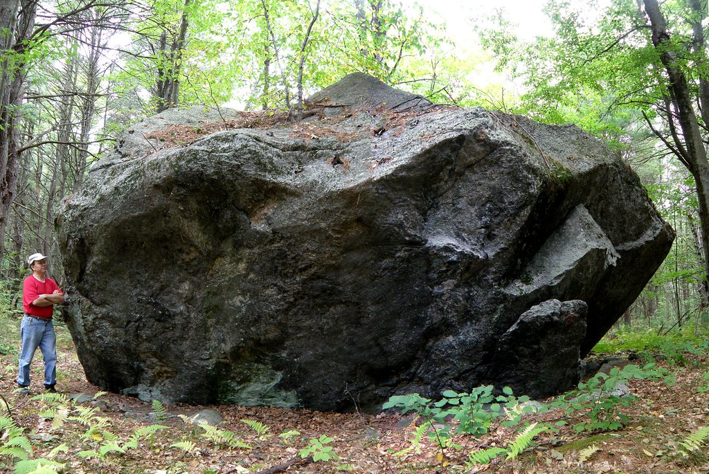
Near the center of town, history reported a "huge boulder" marking the "exact geographical center of town". One boulder seems to fit the location.

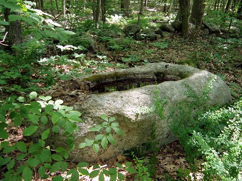
On an abandoned section of roadway running through the woods, a stone watering trough was located.

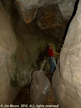
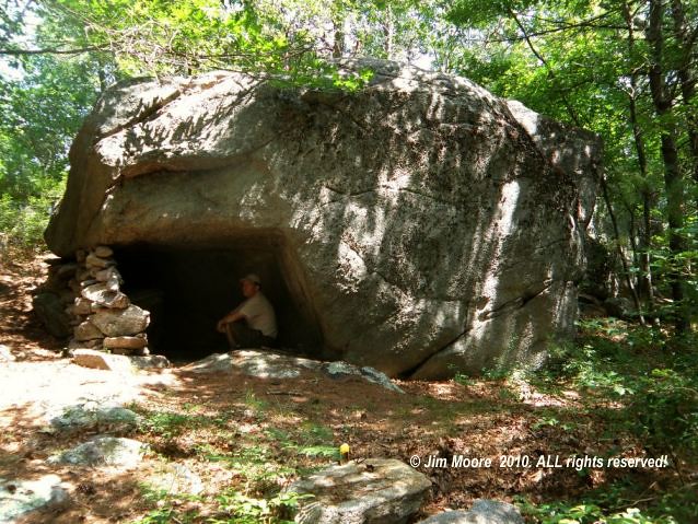
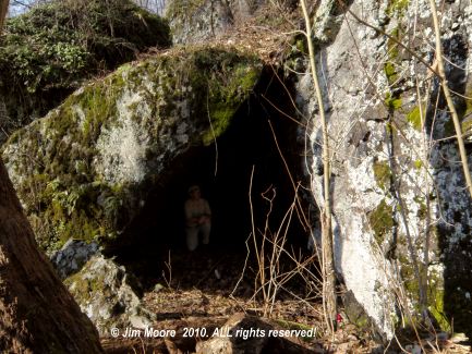
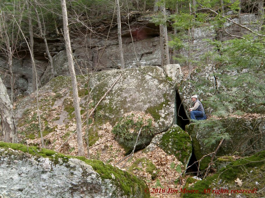
Farther into the wilds lay the Lion's Den, a geologic feature comprised of a ledge and natural arch of rock separated from the main face by several feet. One can enter this space between rocks through an opening in the base of the arch.

An extensive search for the Indian's Cave followed but nothing definitive was brought to light. It apparently was a boulder that lay against a ledge. Many ledges were seen in the area where history recorded its location but none had the boulder described. Could it be the boulder has rolled away downhill?

A rocking stone or "Teeter Rock" was also said to exist in this same section of town, but again, this did not show itself.

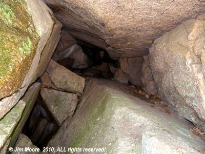
Before heading southeastward to camp, a quick jump into the woods was made to search for another Devil's Den. Amongst the relentless onslaught of mosquitoes and deer flies, a fast walk-through the forest turned up a nice set of ledges honeycombed with small caves. A more extensive investigation was left for better days.
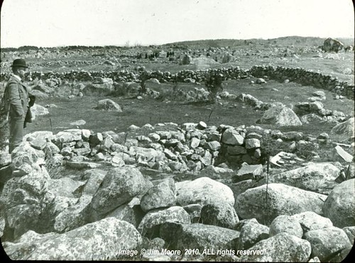


Ledge quarried for slate. Circa: 1870s


Day Two: After a night of heavy thunderstorms, the air was thicker with humidity than the previous day. But on up into the land of Brookfields was my destination. I had been here the previous year in an unsuccessful search for an Indian shelter cave that was home to the last of the Quaboag Indians. On this quest - I was more triumphal locating the rocky ledge and nearby features of a well and chimney leftover from the days of a previous landowner.

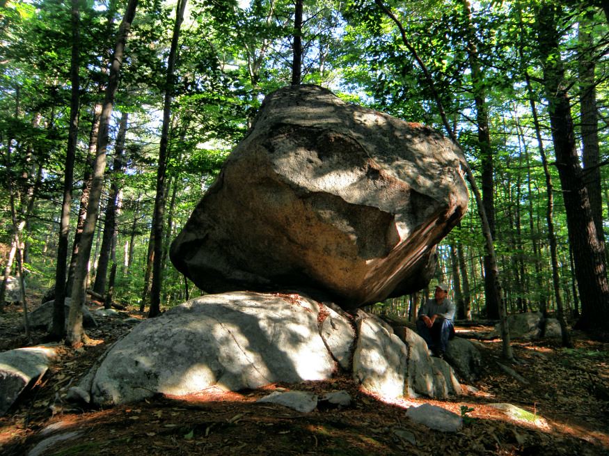
One town to the east, investigation was made of an old postcard known simply as "ledges". My suspicions were these ledges may have been part of an old slate quarrying operation and that proved to be true. I quickly looked for a stone chamber in town but since entry lay through the parking lot of a (opened) business, I deferred on this one to a later date. Next I killed a couple of productive hours (out of the heat) in the local library where sifting through their records obtained information on the slate quarry, another stone chamber, and a balancing rock.

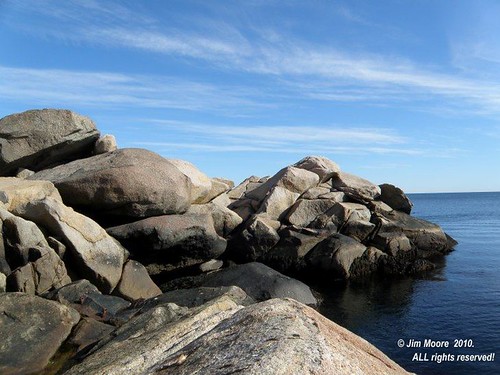
Retreating to the south, I ended not far from the Connecticut border, trying to outrace the coming rain. I located my site in Dennison Rock just as the heavens opened up and a friendly neighbor invited me in to stay dry. A while later, the rain abated enough for me to venture out for photographs. Just enough - as a night of constant rain began on the drive back to camp.

Day Three: Juggling the possibilities of what to do before returning home, I faced another day of intense heat and humidity. So I opted for the casual, somewhat leisurely option, of working my way back through the Quabbin Reservoir region.

Pulling in to the Rock House Reservation, I remembered an old record of glacial scratches on a rock across from it's entrance. This happened to be a large, heavily fractured, glacial boulder that caught my attention on each previous pass through the area. There are some indications of glacial movement across this rock but I would not say they are significant. Of greater interest, I found a nice talus cave in the broken rock alongside the rock outcrop.

Closer to Quabbin, I stopped only briefly to look for two sites from old postcards: a stone drinking fountain and "Reflection Rocks", a pastoral scene of rocks within a river. Neither were located.

Next stop was to look at the progress of East Quabbin Land Trust's project at Indian Rock before once again taking on heat and bugs in an unsuccessful attempt to located the site of an historical reference to a natural bridge within the Quabbin woodlands.

Finishing up, I passed by the 'center of town boulder' seen two days previous for a couple of quick photos. Then it was all but to head back over the northern end of Quabbin to pick up the Mohawk Trail on my way back to the Berkshires.


Rock House; early 1900's postcard

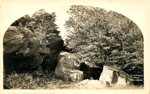
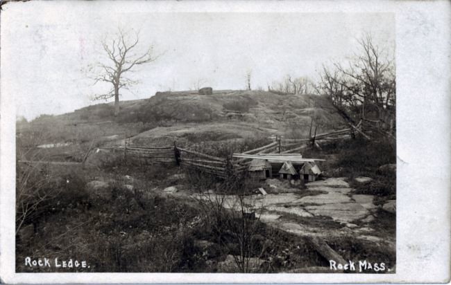
Early 1900s postcard: The Rock House

Monday, May 24, 2010

The Mighty Connecticut


After paddling around local lakes for the past several weeks it was time kick up the learning curve and take on a river - the mighty Connecticut. My main objective was to scout the mid portion of the River in Massachusetts for access points, but I also hoped to work some of my more normal geologic investigations into the mix.

Internet sources mentioned a state owned 'beach' area on the Connecticut's east side so I took that up first. Most of morning was spent trying to locate the site in vain. I talked with two local people, drove to the top of Mount Holyoke looking for DCR (state) employees all without success. The feeling here is it my be an isolated parcel of land and only accessible by water but I will be looking into that further.

Meanwhile back over on the other - west - side of the river the journey took me as far south as the Dinosaur Footprint Park in Holyok. The dino park does offer an expansive view of the river with several rocky ledge outcrops on the river's opposite bank. Somewhere a bit north lies a future watery destination in Titan's Pier, an outcrop lying along side the water.

After briefly looking over an access point at the Oxbow, it was decided to head north for a quieter portion of the river at Sunderland. First order of business was to check some 'non formal' areas of river access and try to verify the exact location of reported riverside rock ledge. After locating the ledge (indeed walking over the top of it) I decided to head downstream to the formal, legitimate access point in town to put in my kayak.

Paddling north - and upstream - presented no real difficulties initially. I landed at the first of the two islands that would be passed, then continued upstream to located the ledge lying along the river opposite island #2. The area between island and shore proved to be a major challange with heavy currents, eddies, and even the occasional whirlpool. But upon making the ledge, a couple quick photos were shot before turning around to ride the current back south. From there it was all but to pack up and head on back over to the Berkshires.

Sunday, May 9, 2010

Since my return from Rhode Island less than three weeks ago several things have been happening. I finally received my long awaited kayak and have been familiarizing myself with its use. One adventure took me down pass the backside of old quarry buildings used in the refining of limestone located on Cheshire Reservoir. Another - out to several islands.

You might ask, what that has to do with geology - or even history. However, I have become increasing aware that certain sites are best - or only accessible from water. Certainly this all plays in to my searching out sea formed caves. And I am reminded of a certain cave report in western Massachusetts that was located on a island. In this instance, a buddy and his canoe were able to paddle me out to my destination although the 'cave' was more of just a rocky formation. So a new activity to keep me going during those hot humid days I don't wish to be in the woods.

Old Berkshire Park, once located just to the east of the southern end of the Ashuwillticook Rail Trail, often appears on old postcards. After a long absence from this picturesque trail I returned one cold, brisk Mother's Day morning to investigate one site visible on one of those old postcards. I also reexamined part of a long ago abandoned road that ran out across the rail trail and entered southern Berkshire Village. This in the days before a Route 8 (approximating the old trolley route) existed from near the present day Berkshire Mall north to the Berkshire Village area.


Island 'cave'- late 1990's

Wednesday, April 21, 2010

Little Rhody


Three days in Rhode Island were devoted primarily to cleaning up some leads and furthering information on previously know sites.

Day One: Rolling on in to the Ocean State's southwest region I revisited a small cave (hereafter: Tippecansett Cave) quite close to the shore of a lake. Like many of the cave/cave formations down this way, it exists in the broken portions of a ledge - or bedrock. Frost action along with gravity assist played an obvious part in these caves genesis.

Farther to the south is a series of caves near the State border with Connecticut. One group is located at what is called locally Dinosaur Rock. It was my hope that with a brand new, WAAS enabled, GPS I might finally settle the issue of what state one or two of these caves lay in. At least one - North Dinosaur Cave is sufficiently east of the State boundary to safely say it belongs to Rhode Island. Upper Dinosaur Cave though was a bit more of a problem. GPS coordinates put it about six meters west - into Connecticut. Still not enough of a margin to say for sure. However, later use of detailed aerial photography pinpoints this cave in Rhode Island - by about twenty feet!

Relocating North Dinosaur Cave was a small task as I had only visited it once previously. With that accomplished, it was time to hike north in search of another reported cave. This definitely took me over into Connecticut and it was the new find of the day. Over fifty feet of cave was located in broken ledge and talus, with multiple entrances.

Retreating to the auto and moving it slightly along the access road, it was time to look once gain at the Pioneer Caves and Glacier Cave. The former is some broken bedrock where a small individual might make their way underground. The latter is more accurately a "rock formation" as it is a vertical crevice in bedrock although a very small chamber exists underground.

A short drive was made south to search out an alternate access route to Narragansett Cave whose only previous visit was the summer of 2007. The trailhead was located prior to retreating across the State to Newport for the night.


cave near the Connecticut - Rhode Island border

Cave near the Connecticut - Rhode Island border


Day Two: A somewhat light and relaxing day was planned that kept me in the immediate vicinity of Newport. I took my traditional trip to an all time favorite in Purgatory. Examining its formation, the conglomerate bedrock that takes it name from, I walked down towards the nearby beach where sand lenses can be found within the bedrock formation. Amongst these lenses are found the Devil Footprints and Squaw Tracks as well as many antique carvings done long ago when Purgatory was a Victorian Age attraction.

Within sight of Purgatory are the Hanging Rocks which were ascended. Spectacular views can be found from the top and in it's giant crevasse (sometimes called the Lion's Mouth) is where George (Bishop) Berkeley is said to have sat while writing.

The Newport area does have a number of historical references to caves. On the drive in to Purgatory the location for one such cave was sought out. But upon leaving the area, I stopped to pursue it further. Supposedly located on the shore of a small lake with limited access, I scanned the shoreline from the opposite side but nary a clue could be found. At that point I retreated to the relative comfort of my room for my own writings.

Low tide brought me out to famous cliffs and Cliff Walk to finish up some business, which has been going on for some years, surrounding the former location of Conrad's Cave. Descending to the sea, a careful examination was given to the cliff and adjacent seawall to see what - if any - of the former grotto might exist. But Conrad's has been fully reclaimed by the sea unless the seawall might hide a portion. Unlikely as a 1950's postcard shows the cave pretty much gone at that time.


Pirate caves - circa 1870


Day Three: Before leaving the area, another favorite once again was visited: the Pirate Caves. This is the finest example of sea caves along the Narragansett Bay. Low tide and some minor wetsuit equipment got me into all but the largest of these formations. And my last stop on the way out of town, was the northern beginning of the Cliff Walk. Somewhere in this area is a geographic (geologic?) feature known as Mary's Seat. Although databases list this as a cliff, it may very well be a rock in the shallow ocean at the end of Easton's Beach.

At this point it was decided to return to the southwest and finish what I started on day one. I checked into caves reported along the North - South trail only to find a number of animal sized 'caves' along with one turkey vulture spooked by my climb into the rocks. Finishing up was a hike from the new access point into Narragansett Cave which took me past many giant erratics. Of greater interest was a huge rock lined ravine, once again with animal sized caves.

Upon completion, it was a long trip up the eastern side of Connecticut to hook up with the Mass Pike home

Sunday, April 4, 2010

Sheeps Cave, Connecticut River Valley

Sheeps Cave


The Easter 'menu' was to bring a routine investigation to a number of relatively tame sites in the northern section of Massachusetts' Connecticut River Valley. 'Routine' is another of those famous last words that often gets lost along the way.

Reaching an area bordering the west shore of the great River, I intended to take a quick look again at Sheeps Cave which lays in the collapse of a large cliff face. Here is where things got sticky as I ended up wandering a section of woods that were eventually found not even the correct location for the cave! Adjusting my location, I moved on only to find the old woods road to the cave lost. But old notes scribbled on my atlas gave me a clue and upon entering the woods once again, I found the old road to be completely obliterated! However, a vague familiarity with the direction to the cliffs eventually got me there where a much more precise GPS location will negate a future repeat of today's difficulties.

The rest of the day was to be devoted to looking at several rock climbing locations, always a good opportunity to view some spectacular examples of the local bedrock. However, ambiguous directions that did not match road names on my atlas led me astray for awhile. But after aborting the attempt to locate my first site, the access road was located by luck as I was driving on to my second destination.

This ledge was no easy feat to locate - or get to. It is most of the way up a large mountainside where evidence of past quarrying was seen. It took several attempts, and back tracking, but eventually way up in the upper reaches of the mountain a massive ledge of gneiss was to be found. And no short piece of rock was this either as it stretched for at least 700 feet with shorter sections continuing still on further.

Although the access route to the noble ledge was marked at intervals with flagging tape and painted saplings, it proved of little help in either the ascent - or descent. I eventually resorted to bushwhacking my way down the mountain which brought me a great stroke of luck. I stumbled into a major abandoned quarry complete with numerous tool marks and plenty of leftover rough cut rock.

So finally making a descent to my car, it was only to drive down and over the Miller's River to catch the Mohawk Trail back west to the Berkshires.

Sunday, March 28, 2010

Return to Stone Hill


This weekend brought a stark, frigid reminder winter is not quite done with us yet. However, under gray skies and near freezing temperatures - I set out. Making my way up to the northern Berkshires, I wanted to finish up a small project at Stone Hill where last summer the brutal heat offered up a whole different envirnoment.

The bedrock of Stone Hill proper is pretty much quartzite, and on my previous visit I saw plenty of ledgy, rocky areas that bore investigation. Additionally, one local farmer reported a site know as Sunset Rock apparently upon the Hill. The broken rock along the western perimeter of the Hill yielded one very small cave among the boulders. Upon reaching a memorial stone bench, I ascended upon the summit and looked for obvious signs of a Sunset Rock where one might get a view off to the west.

Several possible sites, close to one another, presented themselves, and sans foliage, a pretty good vista could be had of the still snow covered westerly Taconic Mountain Range. To finish my exploration in the immediate region, I looked into another access trail that approached Stone Hill from the East.

Taking the scenic route home, I jogged on over western portions of the Mohawk Trail across the top of Berkshire County. My only other stop was to photograph small cave formations along the North Branch of the Hoosic River.

Monday, March 22, 2010


So once again it is time to roll out a brand new season in the outdoors. Many of the unexplored sites that need to be investigated not surprisingly lay far beyond a one day's journey from my home in the most western portion of Massachusetts. They will be dealt with on occasion and most certainly on vacations. But for this day - a return into the Connecticut River Valley. As far as western Massachusetts goes, this is the one region to first thaw out from Winter.

The goal on this day was verification of a site know to rock climbers as Sunbowl. I've had various locations tossed my way over recent years, none of which proved accurate. But finally with something more definitive in hand I set out. Coincidentally, this overlapped with my last year's goal of searching out the trails running through the old section of mountains once known as Paradise.

The walk up into the mountains and locating Sunbowl went surprisingly well. I had suspected this ledge to be one I first came cross four years earlier and I was right. Moving along, I connected with the Paradise trails, looked over a familiar craggy ledge, then traced the route of a mostly obliterated trail back to my car.

Farther north I entered the ledge system once called "Home of the Rocks" which has been explored on many previous occasions. I stopped first at the likely site of Cozy Cave, worked along past the Curve Rock (once again unsuccessfully trying to identify the site an antique photo was taken), finally setting up cameras at the Grand Porch. The overcast skies made good opportunity to finally get half decent photos of this gigantic open-faced rock formation.

I decided since I was in the immediate area of Titan's Pasture, I'd dropped in to the cave located there to see the situation on a bat located there this past year. The bat was not home so I set about exploring the talus caves formations below (and probably within) Titan's Pasture, on over to the Grand Porch. One is fairly 'worthy' at probably 40 feet of passage length. Maybe of greater importance, I recognized it as the first location I came onto some years back when I first took on the investigation of antique photos of rock formations in the area.

With this early season adventure on the wane, I traveled back out of the Valley once again, through mountain towns still showing generous amounts of snow.


Titan's Pasture and it's cave, Connecticut River Valley

Titan's Pasture and it's cave

Thursday, March 11, 2010

Spring???


My, oh my! It seems that Spring has been wanting to come on in for the last week. With last weekend's arrival of the 'perfect' late winter weekend (which in reality was very spring-like) I am reminded the end of the winter sabbatical is close at hand. Only time will tell if this is for real or what some call a 'false Spring'. Per usual, the snow has left the back yards - the higher elevations still deep in Winter.

But time to start preparing once again. A few early projects in the lower elevations and the Connecticut River Valley have already been mapped out. The third week of April will hopefully culminate with a return to Rhode Island and the Narragansett Bay area.


October 2006 @ Cannon Rock

Wednesday, February 10, 2010

Conrad's Cave


It wasn't so long ago, in a place not too far away, that a cave once existed. Conrad's (or Conrad, as one source admonished me) Cave was one of those attractions during the Victorian Age and located in the world famous cliffs of Newport, Rhode Island. The cave's name most likely was derived from a character in the ballet "The Corsaire" (Pirate), which was first produced in 1837, and in turn, was based on the 1814 poem by Lord Byron. In the romantic story, Conrad did indeed have his cave!

But just where did Conrad have his cave at Newport remained somewhat of a mystery. An old atlas had it one block south of the famed Forty Steps. GNIS data, slightly farther to the south in an area out in front of Salve Regina University that is sometimes known as "Cave Cliff". By the early part of this decade, I was already quite familiar with sifting through historical documents, and just getting into antique images, that I decided to make a go of it. It was also around this time, Boston Grotto had a parallel interest and visited a site out in front of, and just slightly south, of the University.

History provided a couple written references (most notably: 1892) to the Cave, but mostly just a passing mention as to one of the sites on your things to see while visiting Newport. There are countless postcard views of the Cliffs and certainly there are a few showing what appear to be a recess - or recesses - within those cliffs. But which one - if any - was Conrad's? Inquiries to more modern authorities only yielded a small, near illegible blurb, about past visits to the site and how, by approximately the 1940's, the trail to the cave had become too dangerous to traverse.

Slowly, over the last couple years, a few clues began to trickle forth. In what was the earliest recorded reference to date that I've found, was the mention of Conrad's in the immediate vicinity of Ellison's Rock. The source was a set of pen and ink drawings done of the Newport area and published in 1848. It was a much easier task to locate Ellison's as the famed Forty Steps makes it's descent to this rock. Another modern day source surface through an eBay dealer selling a postcard view looking out (south) from the Forty Steps and (in the dealer's own words) looking out, and over, the former site of Conrad's Cave. However, the clincher came in the form of an antique piece of photography - a stereoview - showing a rocky cave entrance by lesser know Newport photographer F. Kindler, probably done during the 1860's. And the title? "Forty Steps and Conrad's Cave, Newport, R. I."

So in going back and looking over several old postcards, an entrance - or part thereof - can be seen in that section of the Newport Cliffs. In present time, at low tide, the approximate area does hold a slight shadowy section in the cliffs. The area is heavily riprapped and contains large gravel deposits. A remembrance to Conrad and his Cave.

A circa 1870 view of the Newport Cliffs

This article originally appeared in the Northeastern Caver

4/4/2021: If you haunt the internet long enough, you never can tell what may turn up! The following is a very nice depiction of the Newport Cliffs in the area just described.

Sunday, January 3, 2010

Anatomy of a Profile II


The Stone Face/Profile Rock in more modern times

The Stone Face - or Profile Rock - in more modern times.


Perhaps one of the more intensive investigations over the previous decade was that of the Stone Face on Pelham Brook in northwestern Massachusetts. It was originally brought to my attention by Matt B. over at the Stone Face Gazetteer during the early part of the decade with the arrival of a curious image in my e-mail of an old postcard. Subsequent trips to the Town of Rowe brought forth another postcard of Profile Rock also reported to be along Pelham Brook. The whole investigation was complicated in that both images bore little resemblance to one another.

Perhaps the easier part was hypothesize they were the same rock - despite the obvious difference - due to the matching backgrounds. Next came the Herculean task of finding the proverbial needle in a haystack - one rock along a very long mountain stream. Despite the enormous nature of this task alone, a likely suspect was located. Two trips to this rock alone, with numerous photographs taken, still left me wanting for a better prospect.

A renewed search was made towards the of 2008 after a night of heavy downpours. Pelham Brook is typically your normal sleepy mountain stream but on this day it had become raging torrent. Indeed, at some point in the past once such torrent took out the local bridge downstream also leaving me to wonder if the old location of Stone Face/Profile Rock was somehow affected. Despite the obstacles a second candidate in my search was found perched in the bank just alongside the torrents of water making their way through the ravine. A quick photograph taken, I climbed on out to research my find further while at home the following winter.

The winter passed and another visit to my hypothetical boulder in the Spring of '09 for another - more extensive - set of photographs still yielded nothing definitive. Finally in the waning days of 2009 a breakthrough! Careful, intensive examination, of the more recent photographs revealed several matching points of reference on both postcards. So although this was quite the chore - it has finally paid off.