Vacation has once again arrived. Unfortunately of the hot, humid type during which I generally limit my outdoor activities. But with that said onward I trekked into the great wide open...
Previous to embarking on what was to be primarily a south Worcester County adventure, a local history on one of the Quabbin Reservoir towns came to light, and it furnished enough information - and incentive - to begin my wanderings there.

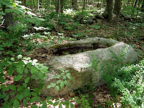
The old stone water trough
Day One: Entering the region just to the east of Quabbin, from the north, I began my search by looking for an old historic spring in Peter Gore's Spring. An issuance of water from the forest floor seemed to be the likely location for this geographic feature.
An underground spring was up next and it proved to be a site I once visited in the past. Some have this on an inventory as a stone chamber and indeed its construction is along those lines.
Bell Rock was revisited after a number of years as it was in the vicinity of some reported caves. Not much was seen for caves other than a small, insignificant overhang on ledge. However, it may be worthwhile to pursue a more expanded search of the area.
Near the center of town, history reported a "huge boulder" marking the "exact geographical center of town". One boulder seems to fit the location.
On an abandoned section of roadway running through the woods, a stone watering trough was located.
Farther into the wilds lay the Lion's Den, a geologic feature comprised of a ledge and natural arch of rock separated from the main face by several feet. One can enter this space between rocks through an opening in the base of the arch.
An extensive search for the Indian's Cave followed but nothing definitive was brought to light. It apparently was a boulder that lay against a ledge. Many ledges were seen in the area where history recorded its location but none had the boulder described. Could it be the boulder has rolled away downhill?
A rocking stone or "Teeter Rock" was also said to exist in this same section of town, but again, this did not show itself.
Before heading southeastward to camp, a quick jump into the woods was made to search for another Devil's Den. Amongst the relentless onslaught of mosquitoes and deer flies, a fast walk-through the forest turned up a nice set of ledges honeycombed with small caves. A more extensive investigation was left for better days.
Day Two: After a night of heavy thunderstorms, the air was thicker with humidity than the previous day. But on up into the land of Brookfields was my destination. I had been here the previous year in an unsuccessful search for an Indian shelter cave that was home to the last of the Quaboag Indians. On this quest - I was more triumphal locating the rocky ledge and nearby features of a well and chimney leftover from the days of a previous landowner.
One town to the east, investigation was made of an old postcard known simply as "ledges". My suspicions were these ledges may have been part of an old slate quarrying operation and that proved to be true. I quickly looked for a stone chamber in town but since entry lay through the parking lot of a (opened) business, I deferred on this one to a later date. Next I killed a couple of productive hours (out of the heat) in the local library where sifting through their records obtained information on the slate quarry, another stone chamber, and a balancing rock.
Retreating to the south, I ended not far from the Connecticut border, trying to outrace the coming rain. I located my site in Dennison Rock just as the heavens opened up and a friendly neighbor invited me in to stay dry. A while later, the rain abated enough for me to venture out for photographs. Just enough - as a night of constant rain began on the drive back to camp.
Day Three: Juggling the possibilities of what to do before returning home, I faced another day of intense heat and humidity. So I opted for the casual, somewhat leisurely option, of working my way back through the Quabbin Reservoir region.
Pulling in to the Rock House Reservation, I remembered an old record of glacial scratches on a rock across from it's entrance. This happened to be a large, heavily fractured, glacial boulder that caught my attention on each previous pass through the area. There are some indications of glacial movement across this rock but I would not say they are significant. Of greater interest, I found a nice talus cave in the broken rock alongside the rock outcrop.
Closer to Quabbin, I stopped only briefly to look for two sites from old postcards: a stone drinking fountain and "Reflection Rocks", a pastoral scene of rocks within a river. Neither were located.
Next stop was to look at the progress of East Quabbin Land Trust's project at Indian Rock before once again taking on heat and bugs in an unsuccessful attempt to located the site of an historical reference to a natural bridge within the Quabbin woodlands.
Finishing up, I passed by the 'center of town boulder' seen two days previous for a couple of quick photos. Then it was all but to head back over the northern end of Quabbin to pick up the Mohawk Trail on my way back to the Berkshires.

Early 1900s postcard: The Rock House
