The Great Frog Boulder - circa 1900
With October comes the annual trek on up into Essex County. With a bountiful list of sites and topics to cover, I headed on up by starting off with my usual route - the Mohawk Trail.
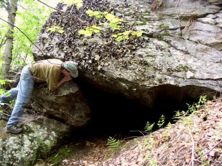
At least every other year (lately: every year) I put some time into Lynn and surrounding towns, this day taking me back to the great urban park Lynn Woods. Some years back I first visited the Great Frog Boulder (once known as the Great Dwarf Rock) but never took in the perspective of a frog. A different day and a different angle brought out the (somewhat) crude resemblance to a frog crouching. Even more astounding was the circumference of this great boulder at almost 120 feet making it amongst the most 'worthy' in Massachusetts. It might be worth mentioning at this point that large glacial erratics (indeed: erratics in general) are quite common to this part of the State.
After finishing up at the Frog I moved on to the Wolf Pits, ancient relics from the past. These are a couple stone lined pits whose purpose (as the name suggests) were to capture wolves during the colonial era. Some pipe remains from years past when it was there to protect the more modern day explorer from falling in.
South Peabody was my next destination where I was surprised to find in recent years that a thriving quarrying operation had once operated. Indeed, this whole area was explored by the Essex Institute around the middle of the nineteenth century where various rocks and caves are listed amongst their writings. I did find a few old quarry sites but the usual case prevailed where urban sprawl has mostly taken over the area. Most interesting was a piece of conservation land that survived. Within its boundaries were a huge mass of glacial boulders including one gigantic rock of the perched/'balanced' type.
Further up the coast, on one of the many beaches, I had wanted to look into the site of an old postcard called the Sentinel. However, after much driving around the neighborhood, I never did come up with access to the beach. Later that night, a Gloucester source was able to fill me in and a future visit will follow.
Finally arriving in Gloucester, where I was to stay the next three nights, I took in Mount Ann. Having read about this mountain for many years, it was great to finally see it in person. It is topped by several somewhat flat rocky outcrops. Erratics abound including one ancient inscription: 1896. Two other huge boulders were also seen off in the woods on both the journey in - and out.
Day Two: This day was planned to meet up with a renown local authority on historical sites in Newbury: Dick C. I decided to incorporate a couple of visits while winding my way northwesterly and the first stop was Ipswich.
Ipswich has the most 'celebrated' example of Devil's footprints in Massachusetts. Along with that comes the story of preacher George Whitefield throwing the Devil off the nearby church after a struggle thus explaining the origin of the footprint. The print featured is marked within a painted circle and is a shallow incised marking. I have always thought (certainly individual opinions will vary) this to one the weakest examples of these features as it only very vaguely resembles a human print. There are also those that look to be cloven hoof prints. A pretty good search of the rocky outcrop did bring up lesser foot-like formations but the real treasure was finding a good example from the cloven hoof variety.
Moving on up to Rowley I got a look at one of the many rocks used by the aforementioned George Whitefield for a sermon. This Pulpit Rock is a long ledgy outcrop pressed into service when the former church adjacent to the site could not hold the throng of individuals showing up to hear Whitefield preach.
Before leaving town I looked into what I expected to be the former site of Sunset Rock. I was under the impression it had been destroyed for the remaking of a local road intersection. Further investigation revealed what really happened was the rock got developed - built on - so now it is closed off to public access.
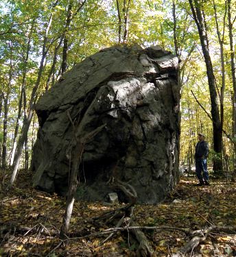
Haystack Boulder On up into Newbury I dropped in once again on Haystack Boulder and one simply called "near Haystack Boulder". Both these large erratics were feature in an early 1900's geologic treatise on Essex County by John Henry Sears. Later on I did confirm with my local expert one known as the Ordway Boulder is also supposed to exist in this area.
The purpose of meeting Dick was to focus on two sites I had no luck in definitely identifying on two previous visits to the area. First up was Gerrish Rock which I imagined to be one of several large glacial boulders lying near a local river. How wrong I was! Reaching river's edge just prior to low tide, Dick pointed out the very top of a rock just starting to show itself above water. As we watched for the next fifteen minutes more and more of Gerrish Rock would slowly emerge. Changing positions on the river's shoreline we were able to see a large portion of the rock would remain just under water. Perhaps a lower low tide might bring it forth.
Dick and I then relocated our cars a bit where we had to tramp over hill and through marshes to see the local Balance Rock. Of course it would not be much of a rock without a story! This one has pirate treasure buried nearby and the rock marked with a letter - or arrow of sorts - that was to help relocate that treasure. Upon finishing our day's adventure, Dick was most generous and helpful in providing additional information to pursue other sites in the future.
I awoke to the rains coming down but an optimistic weather forecast had the rains moving out possibly in the early. So treating myself to breakfast at the local Friendly's, I poured over maps and my itinerary to see what might be accomplished even during a moderated rainfall. One self proclaimed "Old Hippie" (and my local expert on a number of topics including the aforementioned Mount Ann) had peaked my curiosity during a social meeting the previous evening. Asking me how much I had seen of the local quarrying operations I had to confess very little. Although most think fish when Gloucester comes to mind, right in there (and first on my list!) is rocks - as in a once thriving quarrying industry. So setting off north, up the western side of Cape Ann, I motored but first making a stop in the Goose Cove area.
Day Three: I awoke to the rains coming down but an optimistic weather forecast had the rains moving out possibly in the early. So treating myself to breakfast at the local Friendly's, I poured over maps and my itinerary to see what might be accomplished even during a moderated rainfall. One self proclaimed "Old Hippie" (and my local expert on a number of topics including the aforementioned Mount Ann) had peaked my curiosity during a social meeting the previous evening. Asking me how much I had seen of the local quarrying operations I had to confess very little. Although most think fish when Gloucester comes to mind, right in there (and first on my list!) is rocks - as in a once thriving quarrying industry. So setting off north, up the western side of Cape Ann, I motored but first making a stop in the Goose Cove area.

Through a rainy lens: cellar hole marker # 26Part of the Dogtown lore are rocks inscribed (not personally) by Roger Babson some years back. Usually what one hears are the boulders with the mottoes expressing certain morals or virtues. Also amongst the rocks can be found numbers which labeled the cellar hole locations for past families within Dogtown. Most familiar to the Dogtown traveler are those on the road leading directly from the west to old Dogtown Square. However others existed along the old Dogtown Common Road now partially submerged by Goose Cove Reservoir. I have seen one or two of these in the past but this rainy day proved very productive indeed! Near the reservoir was a rock partially hidden by the brush where long ago someone had done (what appears to be) a 'test' - or preliminary - carving. Part of the rock cut away with several roundish holes inside that area. But within the modern suburban neighborhood, some of Babson's work still remained carved on boulders in modern day front yards.
Turning once again northward and following the coast, a few of the old Lanesville quarries were visible from the road and one or two smaller ones I hike in a short distance to view. A brief stop ensued at Halibut Point where one can find a park and quarry accessible to the public. Here the trip turned southward only to stop for a brief glimpse of the Cathedral Rock area (much explored in the past) and stopping at the Granite Pier to give a token look at the coastline for Profile Rock, Devil's Den, and Rockport's Oldest Inhabitant (profile formation) which I've done on several past occasions without success. In this area is a keystone bridge but leading to other old quarries now off limits as part of Rockport's water supply.
Coming down the coast just as low tide was arriving, I made visits to Long Beach to match rocks from an old postcard and Good Harbor Beach where the Viking's Daughter, another profile formation, once resided. Either it no longer exists or has been hidden away by change as I did not observe her. This particular low tide was far enough out for me to get a good view on a certain section of Bass Rocks I have not been able to observe in the past. Exposed for my eyes were an "Old Man" and a minor cave formation. Farther down the coast, an old favorite in the George Washington profile and a confirmation on the site from an old postcard: Money Rock.

Rayne Adams boulderAs I was chowing down my favorite local pizza (now mid afternoon) the rain mostly stopped and even a bit of blue sky and sun began to come out. Deciding to 'go for it' I headed off for my traditional Dogtown hike trying to incorporate some previously unseen areas and some old favorites. So going north from the Dogtown Road I eventually ended up quite near to earlier in the day by Goose Cove Reservoir. I hoped to find more cellar hole markers on the other side of the reservoir but on this trek only one, along with the Rayne Adams boulder, was seen. Eventually swinging south by Abram Wharf's old homestead and Granny Day's Swamp, I arrived in Dogtown Square. Near here I revisited the motto "If work stops values decay" and tried to match the Pearce cellar hole #23 (rock seems to be missing) to an old postcard of the same. As the day was waning, I headed back out and visited the "Never try never win" and Jas Merry rocks where one marks the 'first attack' by a bull and another nearby where he died.
Day Four: Before leaving Cape Ann, one more stop was in order: Red Rocks. This is the local name for a section of Harvey Mountain, diagonally across Rt. 128 from Mount Ann, and once all considered part of Thompson Mountain. This is the favorite local area for rock climbing and well deserved. I climbed to the summit area after passing one giant perched erratic (circumference in excess of 60 feet) and an obvious ledge used by climbers. The summit afforded a worthwhile view all the way to the ocean along with numerous erratics and, if one were to use a bit of imagination, some of those old 'footprint' formations. Rounding the summit and coming off the opposite side, I got to view an even more spectacular set of climbing ledges than passed on the way in.
Boulder along the Bay Circuit Path Turning my attention more westward, Cape Ann was finally left behind in favor of Andover. Here, it was decided, to seek out three different conservation properties before making the trip home. What was taken in between those properties included a former Native American soapstone quarry, giant erratic, Bay Circuit Trail, Sunset Rock, and Indian Ridge - a large esker.